

20160911_110534.gpx
A cycling route starting in Cadipietra, Trentino-Alto Adige, Italy.
Overview
About this route
TAHUNA track
- -:--
- Duration
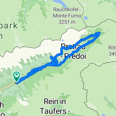
- 7.2 km
- Distance
- 507 m
- Ascent
- 100 m
- Descent
- ---
- Avg. speed
- ---
- Max. altitude
Route quality
Waytypes & surfaces along the route
Waytypes
Quiet road
4.2 km
(58 %)
Track
1.6 km
(22 %)
Surfaces
Paved
2.7 km
(38 %)
Unpaved
1.9 km
(26 %)
Asphalt
2.7 km
(38 %)
Ground
1.2 km
(16 %)
Route highlights
Points of interest along the route
Point of interest after 4.1 km
46°59.436' 11°57.033'
Continue with Bikemap
Use, edit, or download this cycling route
You would like to ride 20160911_110534.gpx or customize it for your own trip? Here is what you can do with this Bikemap route:
Free features
- Save this route as favorite or in collections
- Copy & plan your own version of this route
- Sync your route with Garmin or Wahoo
Premium features
Free trial for 3 days, or one-time payment. More about Bikemap Premium.
- Navigate this route on iOS & Android
- Export a GPX / KML file of this route
- Create your custom printout (try it for free)
- Download this route for offline navigation
Discover more Premium features.
Get Bikemap PremiumFrom our community
Other popular routes starting in Cadipietra
 Steinhaus - Sand in Taufers
- Distance
- 28.9 km
- Ascent
- 307 m
- Descent
- 309 m
- Location
- Cadipietra, Trentino-Alto Adige, Italy
 Steinhaus-Samhütten-Tauernalm-Schluichalm
- Distance
- 44.9 km
- Ascent
- 1,647 m
- Descent
- 1,647 m
- Location
- Cadipietra, Trentino-Alto Adige, Italy
 Straße ohne Straßennamen, Gemeinde Ahrntal nach Keschbmaberg 10, Valle Aurina
- Distance
- 1.1 km
- Ascent
- 101 m
- Descent
- 28 m
- Location
- Cadipietra, Trentino-Alto Adige, Italy
 Riesenfernerrunde
- Distance
- 107.4 km
- Ascent
- 1,921 m
- Descent
- 1,925 m
- Location
- Cadipietra, Trentino-Alto Adige, Italy
 Escursione invernale da Riva a InderedeAlm
- Distance
- 7.2 km
- Ascent
- 290 m
- Descent
- 288 m
- Location
- Cadipietra, Trentino-Alto Adige, Italy
 Malga Hofschaenke-eder
- Distance
- 1.2 km
- Ascent
- 146 m
- Descent
- 21 m
- Location
- Cadipietra, Trentino-Alto Adige, Italy
 Da Riva a Campo Tures (variante con cascate)
- Distance
- 12.1 km
- Ascent
- 452 m
- Descent
- 1,169 m
- Location
- Cadipietra, Trentino-Alto Adige, Italy
 Amonti&Lunaris - Klausberg
- Distance
- 24.8 km
- Ascent
- 1,339 m
- Descent
- 1,336 m
- Location
- Cadipietra, Trentino-Alto Adige, Italy
Open it in the app