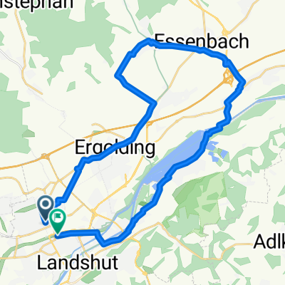
2017 5. Tag Rottenburg a.d. Laaber
A cycling route starting in Landshut, Bavaria, Germany.
Overview
About this route
Date: Â Â Â 02.08.2017
Distance: Â Â Â Â Â Â 96.5 km
Time: Â Â Â Â Â Â Â Â 04:48 h
Elevation gain: Â Â Â 610 m
Max speed: Â Â Â Â Â 52.5 km/h
Avg speed: Â Â Â Â Â 20.1 km/h
Calories burned: Â Â Â 2715 kcal
Temp:       23-31 °C
Wind: Â Â Â Â Â Â Â Â Â Â 8 km/h
Weather: clear sky - sunny
- -:--
- Duration
- 96.1 km
- Distance
- 422 m
- Ascent
- 422 m
- Descent
- ---
- Avg. speed
- ---
- Max. altitude
Route quality
Waytypes & surfaces along the route
Waytypes
Quiet road
50 km
(52 %)
Road
16.3 km
(17 %)
Surfaces
Paved
69.2 km
(72 %)
Unpaved
2.9 km
(3 %)
Asphalt
67.3 km
(70 %)
Paved (undefined)
1.9 km
(2 %)
Continue with Bikemap
Use, edit, or download this cycling route
You would like to ride 2017 5. Tag Rottenburg a.d. Laaber or customize it for your own trip? Here is what you can do with this Bikemap route:
Free features
- Save this route as favorite or in collections
- Copy & plan your own version of this route
- Split it into stages to create a multi-day tour
- Sync your route with Garmin or Wahoo
Premium features
Free trial for 3 days, or one-time payment. More about Bikemap Premium.
- Navigate this route on iOS & Android
- Export a GPX / KML file of this route
- Create your custom printout (try it for free)
- Download this route for offline navigation
Discover more Premium features.
Get Bikemap PremiumFrom our community
Other popular routes starting in Landshut
Schöne 100 Runde- Distance
- 101.5 km
- Ascent
- 309 m
- Descent
- 307 m
- Location
- Landshut, Bavaria, Germany
Radausflug Siedlerbund Landshut-Mirskofen-Landshut.1- Distance
- 27.5 km
- Ascent
- 60 m
- Descent
- 59 m
- Location
- Landshut, Bavaria, Germany
Route in Landshut- Distance
- 38.8 km
- Ascent
- 483 m
- Descent
- 479 m
- Location
- Landshut, Bavaria, Germany
Isartour Nr. 3- Distance
- 29.2 km
- Ascent
- 66 m
- Descent
- 66 m
- Location
- Landshut, Bavaria, Germany
20150808_085610.gpx- Distance
- 53.4 km
- Ascent
- 45 m
- Descent
- 43 m
- Location
- Landshut, Bavaria, Germany
Landshut - München- Distance
- 75 km
- Ascent
- 124 m
- Descent
- 14 m
- Location
- Landshut, Bavaria, Germany
Mittlere Tour von Ergolding zum Kloster Mallersdorf- Distance
- 80.3 km
- Ascent
- 273 m
- Descent
- 272 m
- Location
- Landshut, Bavaria, Germany
Landshut- Distance
- 37.9 km
- Ascent
- 57 m
- Descent
- 62 m
- Location
- Landshut, Bavaria, Germany
Open it in the app


