

2017 Windecken-Grünberg
A cycling route starting in Nidderau, Hesse, Germany.
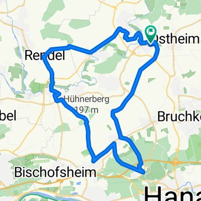
Overview
About this route
it's going well, the sun is coming, but without routes poorly marked, and without tailwind it's unpassable, against the wind therefore, after almost 70 km will continue by train
- -:--
- Duration
- 64.3 km
- Distance
- 368 m
- Ascent
- 230 m
- Descent
- ---
- Avg. speed
- ---
- Max. altitude
Route quality
Waytypes & surfaces along the route
Waytypes
Track
25.7 km
(40 %)
Quiet road
14.1 km
(22 %)
Surfaces
Paved
59.8 km
(93 %)
Unpaved
3.2 km
(5 %)
Asphalt
50.8 km
(79 %)
Paved (undefined)
9 km
(14 %)
Route highlights
Points of interest along the route
Point of interest after 8.1 km
Bäckerei Pause Kaffe und Essen und frisch machen,Clo für sich allein mit Schlüssel,h+k Wasser,perfekt
Point of interest after 10 km
gnadenlos steil 13 % garantiert
Point of interest after 21.3 km
Turm zum Vogelbeobachten,unglaublich viele im Ried,Enten Gänse,Reiher,Schwäne,Störche und und und
Point of interest after 25.3 km
Drecksidioten Schild,weist KEINE Richtung absurd,Kreuzung 4 x Asfalt,und die Autobahn vor der Nase,drüben geht zumindest Straße drunter durch also da...
Point of interest after 37.1 km
Pause gegenüber von Schloß,überall Nazidreck der IB,zum Kotzen!!
Point of interest after 38.1 km
die Bahntrasse endlich...nirgendwo ein Schild ds auf Bahntrasse hinweist
Point of interest after 39.8 km
Hängemattenpause im Wind
Point of interest after 64.3 km
ZUg fährt einem 10 sec vor der Nase weg,armes Drecks Deutschland echt!!
Continue with Bikemap
Use, edit, or download this cycling route
You would like to ride 2017 Windecken-Grünberg or customize it for your own trip? Here is what you can do with this Bikemap route:
Free features
- Save this route as favorite or in collections
- Copy & plan your own version of this route
- Sync your route with Garmin or Wahoo
Premium features
Free trial for 3 days, or one-time payment. More about Bikemap Premium.
- Navigate this route on iOS & Android
- Export a GPX / KML file of this route
- Create your custom printout (try it for free)
- Download this route for offline navigation
Discover more Premium features.
Get Bikemap PremiumFrom our community
Other popular routes starting in Nidderau
 Windecken - Hohe Strasse - Maintal
- Distance
- 33.8 km
- Ascent
- 228 m
- Descent
- 247 m
- Location
- Nidderau, Hesse, Germany
 Südstraße 1, Niddatal nach Freigerichtstraße 42B, Niddatal
- Distance
- 27.4 km
- Ascent
- 430 m
- Descent
- 428 m
- Location
- Nidderau, Hesse, Germany
 Nidderau Runde
- Distance
- 13.9 km
- Ascent
- 87 m
- Descent
- 88 m
- Location
- Nidderau, Hesse, Germany
 BRT_2018-RC03_Ilbenstadt-G-V04
- Distance
- 227.7 km
- Ascent
- 895 m
- Descent
- 907 m
- Location
- Nidderau, Hesse, Germany
 Ostheim - Langenselbold
- Distance
- 24.9 km
- Ascent
- 176 m
- Descent
- 176 m
- Location
- Nidderau, Hesse, Germany
 B45 46, Niddatal nach Freigerichtstraße 44, Niddatal
- Distance
- 14.7 km
- Ascent
- 121 m
- Descent
- 73 m
- Location
- Nidderau, Hesse, Germany
 Nidderau Runde
- Distance
- 16.9 km
- Ascent
- 108 m
- Descent
- 116 m
- Location
- Nidderau, Hesse, Germany
 2017 Windecken-Grünberg
- Distance
- 64.3 km
- Ascent
- 368 m
- Descent
- 230 m
- Location
- Nidderau, Hesse, Germany
Open it in the app