

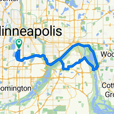
B2B00281 55406>55402 via Cedar Lake Trail, 10th Street
A cycling route starting in Saint Louis Park, Minnesota, United States.
Overview
About this route
- -:--
- Duration
- 9.5 km
- Distance
- 59 m
- Ascent
- 68 m
- Descent
- ---
- Avg. speed
- ---
- Max. altitude
Route highlights
Points of interest along the route
Point of interest after 0.8 km
Follow paved path by School Athletic Fields to trail access connector.
Point of interest after 9.4 km
Contra Flow Bike Lane Available on 2nd Ave So.
Point of interest after 9.4 km
Point of interest after 9.4 km
Point of interest after 9.4 km
Point of interest after 9.4 km
Contra Flow Bike Lane available on 2nd.
Continue with Bikemap
Use, edit, or download this cycling route
You would like to ride B2B00281 55406>55402 via Cedar Lake Trail, 10th Street or customize it for your own trip? Here is what you can do with this Bikemap route:
Free features
- Save this route as favorite or in collections
- Copy & plan your own version of this route
- Sync your route with Garmin or Wahoo
Premium features
Free trial for 3 days, or one-time payment. More about Bikemap Premium.
- Navigate this route on iOS & Android
- Export a GPX / KML file of this route
- Create your custom printout (try it for free)
- Download this route for offline navigation
Discover more Premium features.
Get Bikemap PremiumFrom our community
Other popular routes starting in Saint Louis Park
 Mpls-St Paul Connector
- Distance
- 77.6 km
- Ascent
- 556 m
- Descent
- 556 m
- Location
- Saint Louis Park, Minnesota, United States
 Meadow Ln S, Golden Valley to Tonka Bay Rd, Tonka Bay
- Distance
- 32.4 km
- Ascent
- 130 m
- Descent
- 110 m
- Location
- Saint Louis Park, Minnesota, United States
 SJB Ride 20150515
- Distance
- 34.1 km
- Ascent
- 97 m
- Descent
- 99 m
- Location
- Saint Louis Park, Minnesota, United States
 B2B 00004- 55408-->55435- 28th St and Lyndale Ave South to W77th St, Edina
- Distance
- 13.7 km
- Ascent
- 34 m
- Descent
- 51 m
- Location
- Saint Louis Park, Minnesota, United States
 Regional Trail Loop St. Louis Park
- Distance
- 21.1 km
- Ascent
- 61 m
- Descent
- 63 m
- Location
- Saint Louis Park, Minnesota, United States
 round mtka
- Distance
- 65 km
- Ascent
- 158 m
- Descent
- 159 m
- Location
- Saint Louis Park, Minnesota, United States
 River Bottoms Loop
- Distance
- 79.2 km
- Ascent
- 457 m
- Descent
- 460 m
- Location
- Saint Louis Park, Minnesota, United States
 Midtown Greenway, Minneapolis to Hennepin Ave, Minneapolis
- Distance
- 3.9 km
- Ascent
- 32 m
- Descent
- 32 m
- Location
- Saint Louis Park, Minnesota, United States
Open it in the app