

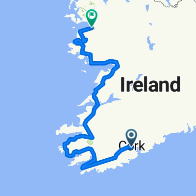
Cork Ballinlough to ferry and east
A cycling route starting in Cork, Munster, Ireland.
Overview
About this route
- -:--
- Duration
- 62 km
- Distance
- 386 m
- Ascent
- 387 m
- Descent
- ---
- Avg. speed
- ---
- Max. altitude

Continue with Bikemap
Use, edit, or download this cycling route
You would like to ride Cork Ballinlough to ferry and east or customize it for your own trip? Here is what you can do with this Bikemap route:
Free features
- Save this route as favorite or in collections
- Copy & plan your own version of this route
- Sync your route with Garmin or Wahoo
Premium features
Free trial for 3 days, or one-time payment. More about Bikemap Premium.
- Navigate this route on iOS & Android
- Export a GPX / KML file of this route
- Create your custom printout (try it for free)
- Download this route for offline navigation
Discover more Premium features.
Get Bikemap PremiumFrom our community
Other popular routes starting in Cork
 wc18_180112
- Distance
- 701.3 km
- Ascent
- 1,244 m
- Descent
- 1,239 m
- Location
- Cork, Munster, Ireland
 Cork Ballinlough to ferry and east
- Distance
- 62 km
- Ascent
- 386 m
- Descent
- 387 m
- Location
- Cork, Munster, Ireland
 Cork - Oysterhaven/sea & back
- Distance
- 77.2 km
- Ascent
- 751 m
- Descent
- 751 m
- Location
- Cork, Munster, Ireland
 Cork-Rosslare
- Distance
- 1,268.4 km
- Ascent
- 1,141 m
- Descent
- 1,148 m
- Location
- Cork, Munster, Ireland
 cork harbour via Carrigaline
- Distance
- 29.6 km
- Ascent
- 16 m
- Descent
- 73 m
- Location
- Cork, Munster, Ireland
 Lengthy bike tour from Cork to Kinsale
- Distance
- 30.2 km
- Ascent
- 351 m
- Descent
- 342 m
- Location
- Cork, Munster, Ireland
 Route from 23–99 North Mall, Cork
- Distance
- 21.9 km
- Ascent
- 0 m
- Descent
- 73 m
- Location
- Cork, Munster, Ireland
 Tag 27: Irland Niemandsland
- Distance
- 94 km
- Ascent
- 1,205 m
- Descent
- 1,148 m
- Location
- Cork, Munster, Ireland
Open it in the app