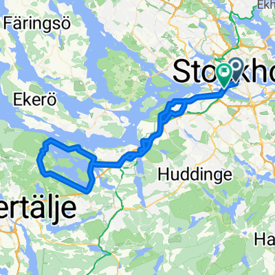
Sztokhol
A cycling route starting in Stockholm, Stockholm County, Sweden.
Overview
About this route
Stockholm
- -:--
- Duration
- 18.7 km
- Distance
- 172 m
- Ascent
- 193 m
- Descent
- ---
- Avg. speed
- ---
- Max. altitude
Route quality
Waytypes & surfaces along the route
Waytypes
Cycleway
6.4 km
(34 %)
Quiet road
5.8 km
(31 %)
Surfaces
Paved
13.1 km
(70 %)
Unpaved
0.9 km
(5 %)
Asphalt
12.7 km
(68 %)
Gravel
0.6 km
(3 %)
Route highlights
Points of interest along the route
Point of interest after 0 km
Panorama Sztokholmu
Point of interest after 2.1 km
Trasa Monteliusvägen
Point of interest after 3.6 km
Bankkajen

Point of interest after 4.1 km
Najmniejszy pomnik w Sztokholmie
Point of interest after 6.6 km
Ratusz miejski – Stadshuset Ratusz miejski (Stadshuset) jest jednym z najważniejszych punktów zwiedzania Sztokholmu. Położony nad wodą Riddarfjärden dominuje w widzianej od południa panoramie miasta. Ratusz uznawany jest za symbol stolicy a trzy złote korony na szczycie jego wysokiej na 106 m wieży symbolizują Szwecję.
Point of interest after 7.5 km
Norrbro
Point of interest after 10 km
ABBA The Museum
Point of interest after 10.8 km
Skansen – miniatura dawnej Szwecji
Point of interest after 13.6 km
Wieża Kaknästornet Pod tarasem, na przedostatnim piętrze jest oszklony „taras”, gdzie mieści się kawiarnia i podniebny bar i gdzie można usiąść sobie i delektować się zarówno widokiem, jak i podniebną „fiką” .
Continue with Bikemap
Use, edit, or download this cycling route
You would like to ride Sztokhol or customize it for your own trip? Here is what you can do with this Bikemap route:
Free features
- Save this route as favorite or in collections
- Copy & plan your own version of this route
- Sync your route with Garmin or Wahoo
Premium features
Free trial for 3 days, or one-time payment. More about Bikemap Premium.
- Navigate this route on iOS & Android
- Export a GPX / KML file of this route
- Create your custom printout (try it for free)
- Download this route for offline navigation
Discover more Premium features.
Get Bikemap PremiumFrom our community
Other popular routes starting in Stockholm
Decathlon 2- Distance
- 35.9 km
- Ascent
- 187 m
- Descent
- 186 m
- Location
- Stockholm, Stockholm County, Sweden
Olvofsgatan - Vaxholm- Distance
- 43 km
- Ascent
- 207 m
- Descent
- 227 m
- Location
- Stockholm, Stockholm County, Sweden
Sztokhol- Distance
- 18.7 km
- Ascent
- 172 m
- Descent
- 193 m
- Location
- Stockholm, Stockholm County, Sweden
Stockholm - Dänemark Fähre- Distance
- 894.8 km
- Ascent
- 618 m
- Descent
- 623 m
- Location
- Stockholm, Stockholm County, Sweden
Stockholm with Louise and James.- Distance
- 14.9 km
- Ascent
- 193 m
- Descent
- 199 m
- Location
- Stockholm, Stockholm County, Sweden
Västmannagatan 46 to Aspviksvägen 28- Distance
- 28.4 km
- Ascent
- 432 m
- Descent
- 466 m
- Location
- Stockholm, Stockholm County, Sweden
Loop to the West- Distance
- 64.9 km
- Ascent
- 268 m
- Descent
- 266 m
- Location
- Stockholm, Stockholm County, Sweden
Wilder Side of Stockholm- Distance
- 157.4 km
- Ascent
- 1,778 m
- Descent
- 1,780 m
- Location
- Stockholm, Stockholm County, Sweden
Open it in the app


