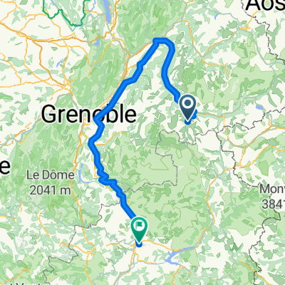
Galibier bis Genf
- 224.1 km
- 2,933 m
- 5,101 m
- Valloire, Auvergne-Rhône-Alpes, France
This time, we do not ride from Valloire over the Col du Galibier, which would be an option, but after a short climb from Valloire we return to the Col du Télégraphe and rush down the beautiful road to St. Michele de Maurienne. After another 15 km downhill, we turn in St. Jean de Maurienne towards the Col de la Croix de Fer. Just behind the town, the mountain ridge rises and the road hugs the ridge tightly. After a short descent, there is another climb of about 10% before the valley behind opens up. Passing the small winter sports resort of St. Jean d’Arves, we then ascend a steep mountainside in tight hairpin bends to the summit of the Col de la Croix de Fer (2,068 m). After about 30 km of climbing and 1,500 m of elevation gain, we have conquered the pass. Then we reach the Col du Glandon (1,924 m) after a descent of about 1 km. There is a cozy restaurant here inviting you to linger. After a total of almost 30 km of descent, we reach the valley just before Le Bourg-d’Oisans. Immediately after the town, the legendary climb of about 14 km begins to Alpe d’Huez. A 'must' for every road cyclist. Countless times Tour de France participants have suffered on this mountain of mountains. And we want to know too – and the legendary time of Marco Pantani with about 37 minutes (in 'doping form') will probably always be out of reach for us. For us, it’s a great feeling to climb the 1,100 m of elevation gain among the encouragement slogans painted on the roads for the Tour. The first 4 km of the ascent have gradients of up to 12% and demand a lot from us – usually in scorching heat. Afterwards, the gradient eases back to 7–8% and we can soon see the winter sports resort at the top. Happy, but spent, we reach Alpe d’Huez at 1,800 m above sea level. After one or two panachés (Radlers), we swoosh back down to the valley, leaving some car drivers behind. Once at the bottom, we load the bikes and travel by bus over the Lautaret Pass to Briançon, our stage town (the highest town in Central Europe at 1,300 m above sea level, about 300 days of sunshine a year, worth a visit).
Quiet road
3.4 km3 %Road
1.1 km1 %Paved
78.1 km(69 %)Asphalt
78.1 km69 %Undefined
35.1 km31 %Free trial for 3 days, or one-time payment. More about Bikemap Premium.
Discover more Premium features.
Get Bikemap PremiumOpen it in the app