
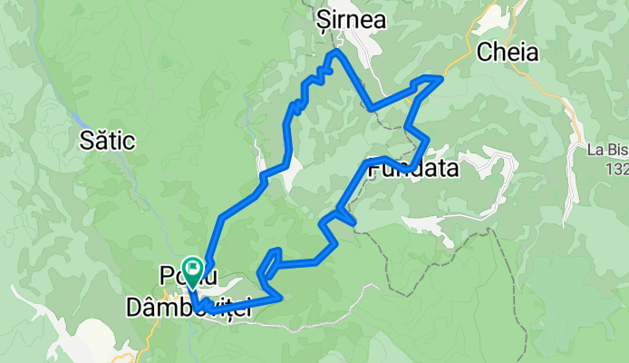
SPRAVEL - Podu Dîmboviței-Dâmbovicioara-Ciocanu-Sirnea-Fundata-Podu Dâmboviței
A cycling route starting in Rucăr, Arges, Romania.
Overview
About this route
- -:--
- Duration
- 32.1 km
- Distance
- 763 m
- Ascent
- 763 m
- Descent
- ---
- Avg. speed
- ---
- Max. altitude

Route quality
Waytypes & surfaces along the route
Waytypes
Cycleway
15.1 km
(47 %)
Track
2.9 km
(9 %)
Surfaces
Paved
25.7 km
(80 %)
Unpaved
5.8 km
(18 %)
Asphalt
25.7 km
(80 %)
Gravel
4.5 km
(14 %)
Route highlights
Points of interest along the route

Photo after 8.6 km
Continue with Bikemap
Use, edit, or download this cycling route
You would like to ride SPRAVEL - Podu Dîmboviței-Dâmbovicioara-Ciocanu-Sirnea-Fundata-Podu Dâmboviței or customize it for your own trip? Here is what you can do with this Bikemap route:
Free features
- Save this route as favorite or in collections
- Copy & plan your own version of this route
- Sync your route with Garmin or Wahoo
Premium features
Free trial for 3 days, or one-time payment. More about Bikemap Premium.
- Navigate this route on iOS & Android
- Export a GPX / KML file of this route
- Create your custom printout (try it for free)
- Download this route for offline navigation
Discover more Premium features.
Get Bikemap PremiumFrom our community
Other popular routes starting in Rucăr
 CAB. VOINA spre Batrana
- Distance
- 4 km
- Ascent
- 281 m
- Descent
- 95 m
- Location
- Rucăr, Arges, Romania
 Cheile Dambovicioarei. Paste 2018
- Distance
- 32.9 km
- Ascent
- 2,498 m
- Descent
- 2,541 m
- Location
- Rucăr, Arges, Romania
 Podu Dambovitei - Oticu
- Distance
- 44.5 km
- Ascent
- 1,284 m
- Descent
- 273 m
- Location
- Rucăr, Arges, Romania
 CAB. VOINA spre Cuca
- Distance
- 3.8 km
- Ascent
- 392 m
- Descent
- 101 m
- Location
- Rucăr, Arges, Romania
 Podul Dambovitei, Fundatica, Sirnea, Ciocanu, Dambovicioara
- Distance
- 40.7 km
- Ascent
- 849 m
- Descent
- 849 m
- Location
- Rucăr, Arges, Romania
 SPRAVEL - Podu Dîmboviței-Dâmbovicioara-Ciocanu-Sirnea-Fundata-Podu Dâmboviței
- Distance
- 32.1 km
- Ascent
- 763 m
- Descent
- 763 m
- Location
- Rucăr, Arges, Romania
 Dambovicioara
- Distance
- 31.5 km
- Ascent
- 676 m
- Descent
- 643 m
- Location
- Rucăr, Arges, Romania
 Podu Dâmboviței Ciocanu Șirnea La Table
- Distance
- 32.2 km
- Ascent
- 878 m
- Descent
- 878 m
- Location
- Rucăr, Arges, Romania
Open it in the app