

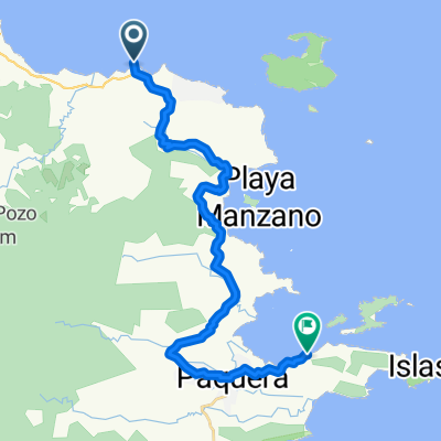
Golfo Nicoya Montezuma- samara- San jose
A cycling route starting in Paquera, Puntarenas Province, Costa Rica.
Overview
About this route
A beautiful road, small hils country side, gravel, beaches and see from Jicaral to Montezuma
One of the routes you can use to get the best experience out of your Costa Rica Cycling trip. Want to learn more just let us know at info@Costaricacycling.com or see our website www.costaricacycling.com
- -:--
- Duration
- 505.9 km
- Distance
- 2,016 m
- Ascent
- 863 m
- Descent
- ---
- Avg. speed
- ---
- Max. altitude

Route quality
Waytypes & surfaces along the route
Waytypes
Quiet road
237.8 km
(47 %)
Road
86 km
(17 %)
Surfaces
Paved
207.4 km
(41 %)
Unpaved
60.7 km
(12 %)
Asphalt
202.4 km
(40 %)
Unpaved (undefined)
30.4 km
(6 %)
Continue with Bikemap
Use, edit, or download this cycling route
You would like to ride Golfo Nicoya Montezuma- samara- San jose or customize it for your own trip? Here is what you can do with this Bikemap route:
Free features
- Save this route as favorite or in collections
- Copy & plan your own version of this route
- Split it into stages to create a multi-day tour
- Sync your route with Garmin or Wahoo
Premium features
Free trial for 3 days, or one-time payment. More about Bikemap Premium.
- Navigate this route on iOS & Android
- Export a GPX / KML file of this route
- Create your custom printout (try it for free)
- Download this route for offline navigation
Discover more Premium features.
Get Bikemap PremiumFrom our community
Other popular routes starting in Paquera
 r128 ROAM
- Distance
- 100.9 km
- Ascent
- 727 m
- Descent
- 719 m
- Location
- Paquera, Puntarenas Province, Costa Rica
 Golfo Nicoya Montezuma- samara- San jose
- Distance
- 505.3 km
- Ascent
- 6,343 m
- Descent
- 6,367 m
- Location
- Paquera, Puntarenas Province, Costa Rica
 9.736° N -85.019° W a 9.735° N -85.016° W
- Distance
- 33.4 km
- Ascent
- 516 m
- Descent
- 521 m
- Location
- Paquera, Puntarenas Province, Costa Rica
 ferry a ferry
- Distance
- 28 km
- Ascent
- 710 m
- Descent
- 701 m
- Location
- Paquera, Puntarenas Province, Costa Rica
 21 to Calle Gomez, Tamarindo
- Distance
- 123 km
- Ascent
- 1,352 m
- Descent
- 1,346 m
- Location
- Paquera, Puntarenas Province, Costa Rica
 De 21 a 21
- Distance
- 130 km
- Ascent
- 2,164 m
- Descent
- 2,169 m
- Location
- Paquera, Puntarenas Province, Costa Rica
 Recovered Route
- Distance
- 6.8 km
- Ascent
- 88 m
- Descent
- 91 m
- Location
- Paquera, Puntarenas Province, Costa Rica
 , Puntarenas to Ruta Nacional 169, San Ramón
- Distance
- 87 km
- Ascent
- 2,239 m
- Descent
- 1,202 m
- Location
- Paquera, Puntarenas Province, Costa Rica
Open it in the app