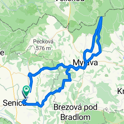
Kamenná vrata
A cycling route starting in Senica, Trnava Region, Slovakia.
Overview
About this route
- -:--
- Duration
- 66.5 km
- Distance
- 884 m
- Ascent
- 884 m
- Descent
- ---
- Avg. speed
- ---
- Max. altitude
Route quality
Waytypes & surfaces along the route
Waytypes
Track
31.2 km
(47 %)
Road
16 km
(24 %)
Surfaces
Paved
19.9 km
(30 %)
Unpaved
29.3 km
(44 %)
Ground
20.6 km
(31 %)
Asphalt
19.3 km
(29 %)
Continue with Bikemap
Use, edit, or download this cycling route
You would like to ride Kamenná vrata or customize it for your own trip? Here is what you can do with this Bikemap route:
Free features
- Save this route as favorite or in collections
- Copy & plan your own version of this route
- Sync your route with Garmin or Wahoo
Premium features
Free trial for 3 days, or one-time payment. More about Bikemap Premium.
- Navigate this route on iOS & Android
- Export a GPX / KML file of this route
- Create your custom printout (try it for free)
- Download this route for offline navigation
Discover more Premium features.
Get Bikemap PremiumFrom our community
Other popular routes starting in Senica
Senica - Šaštín Stráže - Petrova Ves- Distance
- 59.8 km
- Ascent
- 685 m
- Descent
- 684 m
- Location
- Senica, Trnava Region, Slovakia
Hrombaba- Distance
- 58.3 km
- Ascent
- 1,271 m
- Descent
- 1,272 m
- Location
- Senica, Trnava Region, Slovakia
B05 Karpatsky prechod- Distance
- 57.5 km
- Ascent
- 991 m
- Descent
- 1,072 m
- Location
- Senica, Trnava Region, Slovakia
Senica - Radošovce - Holíč- Distance
- 24.1 km
- Ascent
- 143 m
- Descent
- 173 m
- Location
- Senica, Trnava Region, Slovakia
Podbranc-Myjava-Javorina-Bradlo- Distance
- 95.9 km
- Ascent
- 1,451 m
- Descent
- 1,453 m
- Location
- Senica, Trnava Region, Slovakia
Senica - Rozhľadňa Lipka- Distance
- 16.5 km
- Ascent
- 340 m
- Descent
- 129 m
- Location
- Senica, Trnava Region, Slovakia
Cyklotrasa zo Senice na Veľkú Javorinu a späť- Distance
- 92.7 km
- Ascent
- 1,160 m
- Descent
- 1,160 m
- Location
- Senica, Trnava Region, Slovakia
malý okruh Jablonica- Distance
- 28.6 km
- Ascent
- 562 m
- Descent
- 560 m
- Location
- Senica, Trnava Region, Slovakia
Open it in the app


