

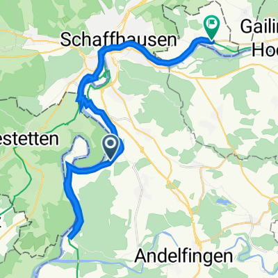
Radrunde vom 13. August, 10:23
A cycling route starting in Marthalen, Canton of Zurich, Switzerland.
Overview
About this route
von Marthalen uber Dettighofen nach Wilchingen
- 1 h 39 min
- Duration
- 27 km
- Distance
- 356 m
- Ascent
- 337 m
- Descent
- 16.4 km/h
- Avg. speed
- ---
- Max. altitude

Route quality
Waytypes & surfaces along the route
Waytypes
Road
8.6 km
(32 %)
Track
6.2 km
(23 %)
Surfaces
Paved
17 km
(63 %)
Unpaved
5.1 km
(19 %)
Asphalt
15.6 km
(58 %)
Gravel
4.3 km
(16 %)
Continue with Bikemap
Use, edit, or download this cycling route
You would like to ride Radrunde vom 13. August, 10:23 or customize it for your own trip? Here is what you can do with this Bikemap route:
Free features
- Save this route as favorite or in collections
- Copy & plan your own version of this route
- Sync your route with Garmin or Wahoo
Premium features
Free trial for 3 days, or one-time payment. More about Bikemap Premium.
- Navigate this route on iOS & Android
- Export a GPX / KML file of this route
- Create your custom printout (try it for free)
- Download this route for offline navigation
Discover more Premium features.
Get Bikemap PremiumFrom our community
Other popular routes starting in Marthalen
 Klettgau
- Distance
- 52.2 km
- Ascent
- 402 m
- Descent
- 402 m
- Location
- Marthalen, Canton of Zurich, Switzerland
 Marthalen - Klettgau - Rundfahrt
- Distance
- 47.1 km
- Ascent
- 378 m
- Descent
- 378 m
- Location
- Marthalen, Canton of Zurich, Switzerland
 Snehová cesta vo Uhwiesen
- Distance
- 4 km
- Ascent
- 97 m
- Descent
- 36 m
- Location
- Marthalen, Canton of Zurich, Switzerland
 Marthalen - Siebnen
- Distance
- 83.2 km
- Ascent
- 519 m
- Descent
- 480 m
- Location
- Marthalen, Canton of Zurich, Switzerland
 hike mit badi
- Distance
- 35.4 km
- Ascent
- 312 m
- Descent
- 203 m
- Location
- Marthalen, Canton of Zurich, Switzerland
 Rundfahrt Marthalen Altikon Ellikon am Rhein
- Distance
- 37.9 km
- Ascent
- 330 m
- Descent
- 329 m
- Location
- Marthalen, Canton of Zurich, Switzerland
 Marthalen - Hochfelden
- Distance
- 56.4 km
- Ascent
- 511 m
- Descent
- 494 m
- Location
- Marthalen, Canton of Zurich, Switzerland
 Rajna mellett
- Distance
- 28.1 km
- Ascent
- 265 m
- Descent
- 255 m
- Location
- Marthalen, Canton of Zurich, Switzerland
Open it in the app