
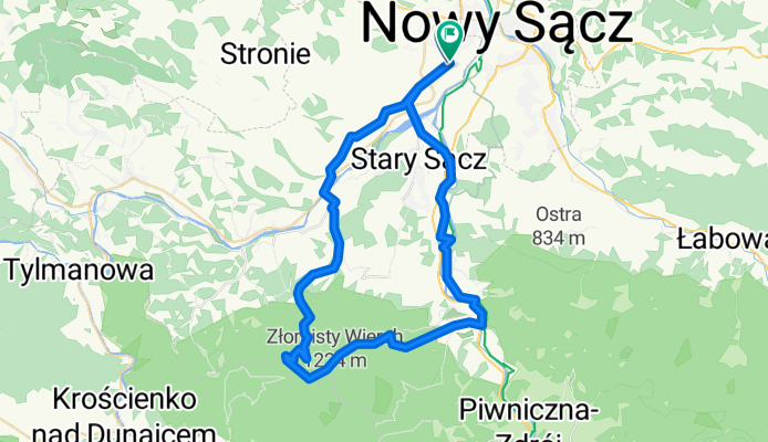
przehyba-rytro niebieskim
A cycling route starting in Gmina Chełmiec, Lesser Poland Voivodeship, Poland.
Overview
About this route
- 4 h 7 min
- Duration
- 54.2 km
- Distance
- 870 m
- Ascent
- 867 m
- Descent
- 13.1 km/h
- Avg. speed
- ---
- Max. altitude
Route photos


Route quality
Waytypes & surfaces along the route
Waytypes
Road
18.5 km
(34 %)
Quiet road
14.6 km
(27 %)
Surfaces
Paved
38.3 km
(71 %)
Unpaved
7.5 km
(14 %)
Asphalt
35.9 km
(66 %)
Ground
6.3 km
(12 %)
Route highlights
Points of interest along the route
Point of interest after 17 km
7 km do celu
Continue with Bikemap
Use, edit, or download this cycling route
You would like to ride przehyba-rytro niebieskim or customize it for your own trip? Here is what you can do with this Bikemap route:
Free features
- Save this route as favorite or in collections
- Copy & plan your own version of this route
- Sync your route with Garmin or Wahoo
Premium features
Free trial for 3 days, or one-time payment. More about Bikemap Premium.
- Navigate this route on iOS & Android
- Export a GPX / KML file of this route
- Create your custom printout (try it for free)
- Download this route for offline navigation
Discover more Premium features.
Get Bikemap PremiumFrom our community
Other popular routes starting in Gmina Chełmiec
 Podrzecze 108, Podegrodzie do Podrzecze 205, Podegrodzie
- Distance
- 19.6 km
- Ascent
- 96 m
- Descent
- 97 m
- Location
- Gmina Chełmiec, Lesser Poland Voivodeship, Poland
 husarska
- Distance
- 12.5 km
- Ascent
- 10 m
- Descent
- 0 m
- Location
- Gmina Chełmiec, Lesser Poland Voivodeship, Poland
 bike tour from 1 września, 14:21
- Distance
- 25.3 km
- Ascent
- 301 m
- Descent
- 302 m
- Location
- Gmina Chełmiec, Lesser Poland Voivodeship, Poland
 przehyba-rytro niebieskim
- Distance
- 54.2 km
- Ascent
- 870 m
- Descent
- 867 m
- Location
- Gmina Chełmiec, Lesser Poland Voivodeship, Poland
 Dunajcowa - biczyce gorne
- Distance
- 12.4 km
- Ascent
- 220 m
- Descent
- 218 m
- Location
- Gmina Chełmiec, Lesser Poland Voivodeship, Poland
 niedzielne pranie ciuchów w terenie
- Distance
- 54.5 km
- Ascent
- 2,509 m
- Descent
- 2,507 m
- Location
- Gmina Chełmiec, Lesser Poland Voivodeship, Poland
 NS Wola Krogulecka platforma
- Distance
- 20.8 km
- Ascent
- 270 m
- Descent
- 28 m
- Location
- Gmina Chełmiec, Lesser Poland Voivodeship, Poland
 Helena - stawy - krótka
- Distance
- 6.6 km
- Ascent
- 9 m
- Descent
- 10 m
- Location
- Gmina Chełmiec, Lesser Poland Voivodeship, Poland
Open it in the app