

Beaujolais vineyards
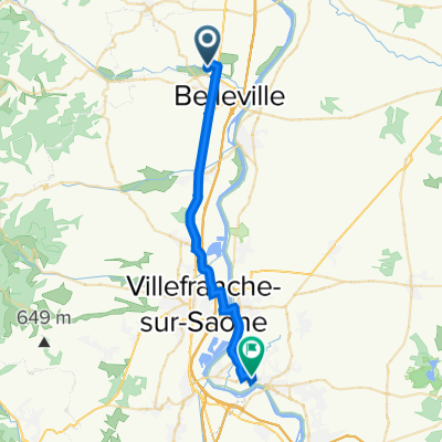
A cycling route starting in Belleville, Auvergne-Rhône-Alpes, France.
Overview
About this route
Start & finish at Belville Station car park. Idyllic ride with enough hills to
- 4 h 51 min
- Duration
- 34.2 km
- Distance
- 326 m
- Ascent
- 325 m
- Descent
- 7 km/h
- Avg. speed
- ---
- Max. altitude

Route photos

Route quality
Waytypes & surfaces along the route
Waytypes
Road
23.6 km
(69 %)
Quiet road
1 km
(3 %)
Surfaces
Paved
19.5 km
(57 %)
Asphalt
19.5 km
(57 %)
Undefined
14.7 km
(43 %)
Continue with Bikemap
Use, edit, or download this cycling route
You would like to ride Beaujolais vineyards or customize it for your own trip? Here is what you can do with this Bikemap route:
Free features
- Save this route as favorite or in collections
- Copy & plan your own version of this route
- Sync your route with Garmin or Wahoo
Premium features
Free trial for 3 days, or one-time payment. More about Bikemap Premium.
- Navigate this route on iOS & Android
- Export a GPX / KML file of this route
- Create your custom printout (try it for free)
- Download this route for offline navigation
Discover more Premium features.
Get Bikemap PremiumFrom our community
Other popular routes starting in Belleville
 5/1_Balcon_Beaujolais_40Km_360m
- Distance
- 40.6 km
- Ascent
- ---
- Descent
- ---
- Location
- Belleville, Auvergne-Rhône-Alpes, France
 Chasse aux cols dans les Monts du Beaujolais
- Distance
- 108.9 km
- Ascent
- 1,873 m
- Descent
- 1,872 m
- Location
- Belleville, Auvergne-Rhône-Alpes, France
 Belleville to Peyrieu
- Distance
- 106.1 km
- Ascent
- 330 m
- Descent
- 266 m
- Location
- Belleville, Auvergne-Rhône-Alpes, France
 4 Avenue Benoît Raclet, Belleville-en-Beaujolais à 442 Route Nationale 6, Saint-Georges-de-Reneins
- Distance
- 8.7 km
- Ascent
- 34 m
- Descent
- 30 m
- Location
- Belleville, Auvergne-Rhône-Alpes, France
 a8 Haut-Beaujolais par la voie verte de Beaujeu
- Distance
- 63.4 km
- Ascent
- 759 m
- Descent
- 757 m
- Location
- Belleville, Auvergne-Rhône-Alpes, France
 Beaujolais vineyards
- Distance
- 34.2 km
- Ascent
- 326 m
- Descent
- 325 m
- Location
- Belleville, Auvergne-Rhône-Alpes, France
 Col Hunting from Belleville
- Distance
- 103.3 km
- Ascent
- 1,357 m
- Descent
- 1,354 m
- Location
- Belleville, Auvergne-Rhône-Alpes, France
 saint jean d'ardiere - Trévoux
- Distance
- 25.1 km
- Ascent
- 109 m
- Descent
- 74 m
- Location
- Belleville, Auvergne-Rhône-Alpes, France
Open it in the app