

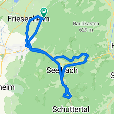
Bärbel-Tour
A cycling route starting in Friesenheim, Baden-Wurttemberg, Germany.
Overview
About this route
Tour of the long straight...
- -:--
- Duration
- 36 km
- Distance
- 133 m
- Ascent
- 112 m
- Descent
- ---
- Avg. speed
- ---
- Max. altitude

Route photos


Route quality
Waytypes & surfaces along the route
Waytypes
Track
13 km
(36 %)
Quiet road
9.7 km
(27 %)
Surfaces
Paved
22.3 km
(62 %)
Unpaved
7.9 km
(22 %)
Asphalt
17.7 km
(49 %)
Paved (undefined)
4.7 km
(13 %)
Continue with Bikemap
Use, edit, or download this cycling route
You would like to ride Bärbel-Tour or customize it for your own trip? Here is what you can do with this Bikemap route:
Free features
- Save this route as favorite or in collections
- Copy & plan your own version of this route
- Sync your route with Garmin or Wahoo
Premium features
Free trial for 3 days, or one-time payment. More about Bikemap Premium.
- Navigate this route on iOS & Android
- Export a GPX / KML file of this route
- Create your custom printout (try it for free)
- Download this route for offline navigation
Discover more Premium features.
Get Bikemap PremiumFrom our community
Other popular routes starting in Friesenheim
 MTB Hausrunde
- Distance
- 43.1 km
- Ascent
- 1,039 m
- Descent
- 1,039 m
- Location
- Friesenheim, Baden-Wurttemberg, Germany
 Friesenheim - Stefans Hütte - Burg Hohengeroldseck
- Distance
- 40.4 km
- Ascent
- 721 m
- Descent
- 721 m
- Location
- Friesenheim, Baden-Wurttemberg, Germany
 OW - Berghaupten - Schönberg- Seelbach - Lahr - OW
- Distance
- 46.9 km
- Ascent
- 499 m
- Descent
- 499 m
- Location
- Friesenheim, Baden-Wurttemberg, Germany
 Kleine Sonntagsrunde
- Distance
- 35.9 km
- Ascent
- 534 m
- Descent
- 535 m
- Location
- Friesenheim, Baden-Wurttemberg, Germany
 Bärbel-Tour
- Distance
- 36 km
- Ascent
- 133 m
- Descent
- 112 m
- Location
- Friesenheim, Baden-Wurttemberg, Germany
 Ow - Kippenh - Mahlb - Schmieh - Sulz - Ow
- Distance
- 37.7 km
- Ascent
- 262 m
- Descent
- 262 m
- Location
- Friesenheim, Baden-Wurttemberg, Germany
 Ried und Elsass
- Distance
- 55.2 km
- Ascent
- 67 m
- Descent
- 67 m
- Location
- Friesenheim, Baden-Wurttemberg, Germany
 Geisberg-Elzach Tour
- Distance
- 90.2 km
- Ascent
- 813 m
- Descent
- 813 m
- Location
- Friesenheim, Baden-Wurttemberg, Germany
Open it in the app