

Etap 3 ( alternatywa ) Zell am See - Grossglockner
A cycling route starting in Zell am See, Salzburg, Austria.
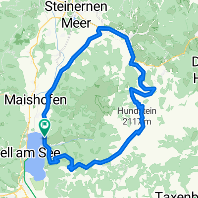
Overview
About this route
Najtrudniejszy etap naszej wyprawy. 37 kilometrowy podjazd z prawie 2000 metrów w górę. Wyjeżdżamy z Zell am See i kierujemy się do Grossglockner Hochalpenstrase, czyli na najwyżej położoną drogę w Alpach. Po 13 kilometrach stosunkowo łatwego podjazdu, rozpoczynamy wspinaczkę, która poprowadzi nas do jednego z najpiękniejszych punktów widokowych – Edelweisspitze 2572 m. Po zaliczeniu tego szczytu kierujemy się na Tauernkogel 2734 m. Jednak mylą się ci którzy myślą ze są już na słynnym Grossglocknerze. Do czoła tego legendarnego lodowca pozostało około 25. W tym krótki zjazd i około 18 kilometrowa wspinaczki. Ale to już scenariusz na następny dzień.
- -:--
- Duration
- 36.5 km
- Distance
- 1,904 m
- Ascent
- 165 m
- Descent
- ---
- Avg. speed
- ---
- Max. altitude

Route quality
Waytypes & surfaces along the route
Waytypes
Road
29.6 km
(81 %)
Cycleway
4.4 km
(12 %)
Surfaces
Paved
34.7 km
(95 %)
Unpaved
1.1 km
(3 %)
Asphalt
34.7 km
(95 %)
Gravel
1.1 km
(3 %)
Undefined
0.7 km
(2 %)
Continue with Bikemap
Use, edit, or download this cycling route
You would like to ride Etap 3 ( alternatywa ) Zell am See - Grossglockner or customize it for your own trip? Here is what you can do with this Bikemap route:
Free features
- Save this route as favorite or in collections
- Copy & plan your own version of this route
- Sync your route with Garmin or Wahoo
Premium features
Free trial for 3 days, or one-time payment. More about Bikemap Premium.
- Navigate this route on iOS & Android
- Export a GPX / KML file of this route
- Create your custom printout (try it for free)
- Download this route for offline navigation
Discover more Premium features.
Get Bikemap PremiumFrom our community
Other popular routes starting in Zell am See
 PŘ 1z - AT2006 - Zell am See - Hundstein
- Distance
- 46.4 km
- Ascent
- 1,498 m
- Descent
- 1,498 m
- Location
- Zell am See, Salzburg, Austria
 Gravel bike route: Seeblickrunde
- Distance
- 37.6 km
- Ascent
- 887 m
- Descent
- 886 m
- Location
- Zell am See, Salzburg, Austria
 Ramseidner Runde
- Distance
- 55.5 km
- Ascent
- 691 m
- Descent
- 693 m
- Location
- Zell am See, Salzburg, Austria
 2014 IRONMAN 70.3 Zell am See / Kaprun
- Distance
- 90.4 km
- Ascent
- 753 m
- Descent
- 753 m
- Location
- Zell am See, Salzburg, Austria
 Zell Am See - Around the lake
- Distance
- 18.6 km
- Ascent
- 124 m
- Descent
- 125 m
- Location
- Zell am See, Salzburg, Austria
 Hundstein
- Distance
- 42 km
- Ascent
- 1,413 m
- Descent
- 1,413 m
- Location
- Zell am See, Salzburg, Austria
 Zell am See - Bad Gastein
- Distance
- 52.2 km
- Ascent
- 1,101 m
- Descent
- 802 m
- Location
- Zell am See, Salzburg, Austria
 Hundsteinrunde
- Distance
- 44 km
- Ascent
- 1,482 m
- Descent
- 1,480 m
- Location
- Zell am See, Salzburg, Austria
Open it in the app