

bike tour through Trenton
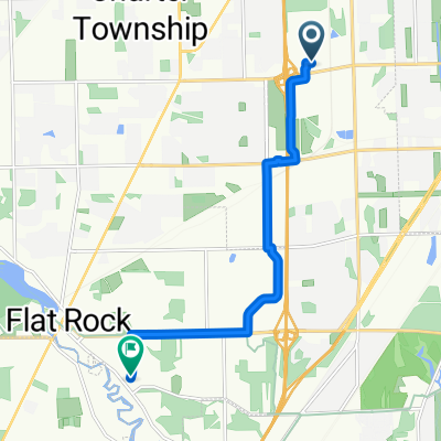
A cycling route starting in Woodhaven, Michigan, United States.
Overview
About this route
Regular bike path route
- -:--
- Duration
- 10.8 km
- Distance
- 25 m
- Ascent
- 27 m
- Descent
- ---
- Avg. speed
- ---
- Max. altitude

Route highlights
Points of interest along the route
Point of interest after 0 km
Continue with Bikemap
Use, edit, or download this cycling route
You would like to ride bike tour through Trenton or customize it for your own trip? Here is what you can do with this Bikemap route:
Free features
- Save this route as favorite or in collections
- Copy & plan your own version of this route
- Sync your route with Garmin or Wahoo
Premium features
Free trial for 3 days, or one-time payment. More about Bikemap Premium.
- Navigate this route on iOS & Android
- Export a GPX / KML file of this route
- Create your custom printout (try it for free)
- Download this route for offline navigation
Discover more Premium features.
Get Bikemap PremiumFrom our community
Other popular routes starting in Woodhaven
 24135 Hall Rd, Woodhaven to Civic Center Park Dr, Woodhaven
- Distance
- 9.5 km
- Ascent
- 7 m
- Descent
- 6 m
- Location
- Woodhaven, Michigan, United States
 21055 West Rd, Woodhaven to 27532 Mayfair Ave, Brownstown Twp
- Distance
- 5.8 km
- Ascent
- 6 m
- Descent
- 9 m
- Location
- Woodhaven, Michigan, United States
 Chipmunk Trail East 21679, Woodhaven to Chipmunk Trail East 21679, Woodhaven
- Distance
- 7.3 km
- Ascent
- 75 m
- Descent
- 37 m
- Location
- Woodhaven, Michigan, United States
 Century Bike Path
- Distance
- 162.2 km
- Ascent
- 67 m
- Descent
- 71 m
- Location
- Woodhaven, Michigan, United States
 West Rd, Woodhaven to Red Cedar Dr, Flat Rock
- Distance
- 10 km
- Ascent
- 28 m
- Descent
- 30 m
- Location
- Woodhaven, Michigan, United States
 Trenton long
- Distance
- 20.3 km
- Ascent
- 99 m
- Descent
- 92 m
- Location
- Woodhaven, Michigan, United States
 Evans Court 4827, Trenton to Evans Court 4827, Trenton
- Distance
- 3.8 km
- Ascent
- 0 m
- Descent
- 0 m
- Location
- Woodhaven, Michigan, United States
 peggy
peggy- Distance
- 0.7 km
- Ascent
- 76 m
- Descent
- 92 m
- Location
- Woodhaven, Michigan, United States
Open it in the app