

Mein erster Alpenpass vom 17. August 2017
A cycling route starting in Schruns, Vorarlberg, Austria.
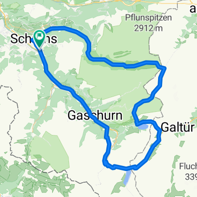
Overview
About this route
Silvretta Hochalpenstrasse und retour durch den Arlbergtunnel mit der Bahn.
Ab Schruns ueber asphaltierten Radweg sanft ansteigend durchs Montafon bis Mautstelle Partenen, 28 Kehren bis Bielerhoehe, lange gerade Abfahrt mit nur 4 Kehren durchs Paznauntal nach Landeck (Achtung, Galerien und Tunnel, Licht am Rad ist sinnvoll). Strasse in sehr gutem sauberen und trockenen Zustand. Verkehr auf der Mautstrecke ertraeglich. Mit dem Zug (alle 2 Stunden) nach Bludenz. Auf dem Radweg zurueck nach Schruns. Etwas 1500Hm, 100km Radstrecke.
- 7 h 52 min
- Duration
- 157.3 km
- Distance
- 4,742 m
- Ascent
- 4,730 m
- Descent
- 20 km/h
- Avg. speed
- ---
- Max. altitude

Continue with Bikemap
Use, edit, or download this cycling route
You would like to ride Mein erster Alpenpass vom 17. August 2017 or customize it for your own trip? Here is what you can do with this Bikemap route:
Free features
- Save this route as favorite or in collections
- Copy & plan your own version of this route
- Split it into stages to create a multi-day tour
- Sync your route with Garmin or Wahoo
Premium features
Free trial for 3 days, or one-time payment. More about Bikemap Premium.
- Navigate this route on iOS & Android
- Export a GPX / KML file of this route
- Create your custom printout (try it for free)
- Download this route for offline navigation
Discover more Premium features.
Get Bikemap PremiumFrom our community
Other popular routes starting in Schruns
 2011_2_Vorarlberg-Tirol-Allgäu-Runde (BAFGOR)_Tschagguns - See
- Distance
- 74.9 km
- Ascent
- 1,398 m
- Descent
- 1,068 m
- Location
- Schruns, Vorarlberg, Austria
 schruns partenen heilbronner hütte silbertal schruns
- Distance
- 75.8 km
- Ascent
- 2,255 m
- Descent
- 2,258 m
- Location
- Schruns, Vorarlberg, Austria
 Schruns-Saarbrücker hütte
- Distance
- 69.1 km
- Ascent
- 1,871 m
- Descent
- 1,875 m
- Location
- Schruns, Vorarlberg, Austria
 M fit Montafon Mountainbike Marathon
- Distance
- 29.4 km
- Ascent
- 377 m
- Descent
- 377 m
- Location
- Schruns, Vorarlberg, Austria
 schruns partenen heilbronner hütte silbertal schruns
- Distance
- 75.7 km
- Ascent
- 2,289 m
- Descent
- 2,290 m
- Location
- Schruns, Vorarlberg, Austria
 Rund um den Itonskopf Tour
- Distance
- 24.4 km
- Ascent
- 1,319 m
- Descent
- 916 m
- Location
- Schruns, Vorarlberg, Austria
 M3 - extrem Montafon Mountainbike Marathon // Teilstrecken nur am Renntag befahrbar!
- Distance
- 134.5 km
- Ascent
- 4,344 m
- Descent
- 4,342 m
- Location
- Schruns, Vorarlberg, Austria
 Silvretta-Hochalpenstraße und Arlbergpaß RR
- Distance
- 138.8 km
- Ascent
- 2,371 m
- Descent
- 2,371 m
- Location
- Schruns, Vorarlberg, Austria
Open it in the app