

Przełęcz Karkonoska & Modré sedlo & Przełęcz Okraj
A cycling route starting in Cieplice Śląskie Zdrój, Lower Silesian Voivodeship, Poland.
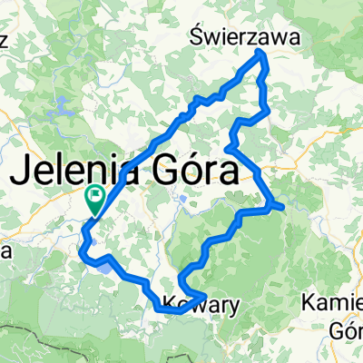
Overview
About this route
Sobieszów - Podgórzyn - Przesieka - Špindlerův Mlýn - Vrchlabí - Lánov - Dolní Dvůr - Pec pod Sněžką - Velká Úpa - Ogorzelec - Leszczyniec - Szarocin - Kamienna Góra - Dębrznik - Sędzisław
- -:--
- Duration
- 117.1 km
- Distance
- 2,197 m
- Ascent
- 2,109 m
- Descent
- ---
- Avg. speed
- ---
- Max. altitude

Continue with Bikemap
Use, edit, or download this cycling route
You would like to ride Przełęcz Karkonoska & Modré sedlo & Przełęcz Okraj or customize it for your own trip? Here is what you can do with this Bikemap route:
Free features
- Save this route as favorite or in collections
- Copy & plan your own version of this route
- Split it into stages to create a multi-day tour
- Sync your route with Garmin or Wahoo
Premium features
Free trial for 3 days, or one-time payment. More about Bikemap Premium.
- Navigate this route on iOS & Android
- Export a GPX / KML file of this route
- Create your custom printout (try it for free)
- Download this route for offline navigation
Discover more Premium features.
Get Bikemap PremiumFrom our community
Other popular routes starting in Cieplice Śląskie Zdrój
 VIII Półmaraton Jeleniogórski
- Distance
- 21.3 km
- Ascent
- 228 m
- Descent
- 225 m
- Location
- Cieplice Śląskie Zdrój, Lower Silesian Voivodeship, Poland
 Sudety (05)
- Distance
- 28.4 km
- Ascent
- 648 m
- Descent
- 648 m
- Location
- Cieplice Śląskie Zdrój, Lower Silesian Voivodeship, Poland
 Karkonosze (ring)
- Distance
- 98.4 km
- Ascent
- 1,402 m
- Descent
- 1,402 m
- Location
- Cieplice Śląskie Zdrój, Lower Silesian Voivodeship, Poland
 Klasyk Karkonoski-GMPA
- Distance
- 75.4 km
- Ascent
- 1,524 m
- Descent
- 1,275 m
- Location
- Cieplice Śląskie Zdrój, Lower Silesian Voivodeship, Poland
 Szklarska przez przesieke i podgorzyn do cieplic
- Distance
- 21.2 km
- Ascent
- 490 m
- Descent
- 198 m
- Location
- Cieplice Śląskie Zdrój, Lower Silesian Voivodeship, Poland
 Jelenia Góra
- Distance
- 83.9 km
- Ascent
- 855 m
- Descent
- 856 m
- Location
- Cieplice Śląskie Zdrój, Lower Silesian Voivodeship, Poland
 Dla mamy
- Distance
- 23.6 km
- Ascent
- 239 m
- Descent
- 237 m
- Location
- Cieplice Śląskie Zdrój, Lower Silesian Voivodeship, Poland
 Trasa 2
- Distance
- 102.2 km
- Ascent
- 893 m
- Descent
- 893 m
- Location
- Cieplice Śląskie Zdrój, Lower Silesian Voivodeship, Poland
Open it in the app