

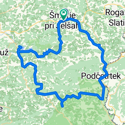
Kozjanska 1
A cycling route starting in Šmarje pri Jelšah, Občina Šmarje pri Jelšah, Slovenia.
Overview
About this route
From Šmarje towards Rogaška, up to the village of Belo, you can follow the cycling path (as long as it runs alongside the railway). If you want to visit Olimje in addition to Podčetrtek, use the Kozkanske 4 route.
- -:--
- Duration
- 59.3 km
- Distance
- 363 m
- Ascent
- 363 m
- Descent
- ---
- Avg. speed
- ---
- Max. altitude

Route quality
Waytypes & surfaces along the route
Waytypes
Road
33.2 km
(56 %)
Quiet road
10.1 km
(17 %)
Surfaces
Paved
13.1 km
(22 %)
Asphalt
12.5 km
(21 %)
Concrete
0.6 km
(1 %)
Undefined
46.3 km
(78 %)
Continue with Bikemap
Use, edit, or download this cycling route
You would like to ride Kozjanska 1 or customize it for your own trip? Here is what you can do with this Bikemap route:
Free features
- Save this route as favorite or in collections
- Copy & plan your own version of this route
- Sync your route with Garmin or Wahoo
Premium features
Free trial for 3 days, or one-time payment. More about Bikemap Premium.
- Navigate this route on iOS & Android
- Export a GPX / KML file of this route
- Create your custom printout (try it for free)
- Download this route for offline navigation
Discover more Premium features.
Get Bikemap PremiumFrom our community
Other popular routes starting in Šmarje pri Jelšah
 Škofija - Boč - Zibika - Škofija
- Distance
- 50.1 km
- Ascent
- 1,100 m
- Descent
- 1,100 m
- Location
- Šmarje pri Jelšah, Občina Šmarje pri Jelšah, Slovenia
 Šmarje pri Jelšah to Šmarje pri Jelšah 67 km
- Distance
- 63 km
- Ascent
- 1,254 m
- Descent
- 1,255 m
- Location
- Šmarje pri Jelšah, Občina Šmarje pri Jelšah, Slovenia
 Kozjanska 1
- Distance
- 59.3 km
- Ascent
- 363 m
- Descent
- 363 m
- Location
- Šmarje pri Jelšah, Občina Šmarje pri Jelšah, Slovenia
 Šmarje pri Jelšah to Rogatec
- Distance
- 34.5 km
- Ascent
- 709 m
- Descent
- 564 m
- Location
- Šmarje pri Jelšah, Občina Šmarje pri Jelšah, Slovenia
 EV9-rogslatina-brezice-2013-05-19
- Distance
- 50.9 km
- Ascent
- 402 m
- Descent
- 483 m
- Location
- Šmarje pri Jelšah, Občina Šmarje pri Jelšah, Slovenia
 Obrtniška ulica 11 to Obrtniška ulica 11
- Distance
- 32.1 km
- Ascent
- 101 m
- Descent
- 107 m
- Location
- Šmarje pri Jelšah, Občina Šmarje pri Jelšah, Slovenia
 Šentvid-Slivniško jezero-Slom-Ponikva-Šentvid
- Distance
- 23.8 km
- Ascent
- 436 m
- Descent
- 433 m
- Location
- Šmarje pri Jelšah, Občina Šmarje pri Jelšah, Slovenia
 Škofija - Slivniško jezero - Škofija (krožna)
- Distance
- 39.6 km
- Ascent
- 401 m
- Descent
- 402 m
- Location
- Šmarje pri Jelšah, Občina Šmarje pri Jelšah, Slovenia
Open it in the app