

Gleiming Obertauern
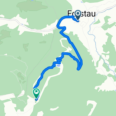
A cycling route starting in Forstau, Salzburg, Austria.
Overview
About this route
The odometer showed 69 km. The elevation gain matches according to the Fitbit watch. The last battery bar was nearly empty 1 km before the end of the tour on the mountain. We had to ride a lot on the road because many bike paths along the streams were closed due to storms. They are working very diligently on renovations here.
- -:--
- Duration
- 66.5 km
- Distance
- 1,036 m
- Ascent
- 1,036 m
- Descent
- ---
- Avg. speed
- ---
- Max. altitude

Route quality
Waytypes & surfaces along the route
Waytypes
Track
24.6 km
(37 %)
Quiet road
10.6 km
(16 %)
Surfaces
Paved
37.3 km
(56 %)
Unpaved
25.3 km
(38 %)
Asphalt
37.3 km
(56 %)
Gravel
24.6 km
(37 %)
Continue with Bikemap
Use, edit, or download this cycling route
You would like to ride Gleiming Obertauern or customize it for your own trip? Here is what you can do with this Bikemap route:
Free features
- Save this route as favorite or in collections
- Copy & plan your own version of this route
- Sync your route with Garmin or Wahoo
Premium features
Free trial for 3 days, or one-time payment. More about Bikemap Premium.
- Navigate this route on iOS & Android
- Export a GPX / KML file of this route
- Create your custom printout (try it for free)
- Download this route for offline navigation
Discover more Premium features.
Get Bikemap PremiumFrom our community
Other popular routes starting in Forstau
 Gleiming Filzmoos Eben Runde
- Distance
- 49.8 km
- Ascent
- 497 m
- Descent
- 497 m
- Location
- Forstau, Salzburg, Austria
 Gleiming 2, Schladming to Gleiming 2, Schladming
- Distance
- 29 km
- Ascent
- 555 m
- Descent
- 1,163 m
- Location
- Forstau, Salzburg, Austria
 Forstau - Oberhüttensee
- Distance
- 14.9 km
- Ascent
- 986 m
- Descent
- 13 m
- Location
- Forstau, Salzburg, Austria
 Panorama Tour (Reiteralm)
- Distance
- 54.8 km
- Ascent
- 1,268 m
- Descent
- 1,268 m
- Location
- Forstau, Salzburg, Austria
 Gleiming Ramsau
- Distance
- 38.3 km
- Ascent
- 736 m
- Descent
- 737 m
- Location
- Forstau, Salzburg, Austria
 Forstau nach Fagerstraße, Forstau
- Distance
- 5.5 km
- Ascent
- 687 m
- Descent
- 70 m
- Location
- Forstau, Salzburg, Austria
 Nova trasa 2.den
- Distance
- 53.2 km
- Ascent
- 296 m
- Descent
- 275 m
- Location
- Forstau, Salzburg, Austria
 Rakousko 2012-9.den-22.7.Ne
- Distance
- 79.6 km
- Ascent
- 424 m
- Descent
- 502 m
- Location
- Forstau, Salzburg, Austria
Open it in the app