

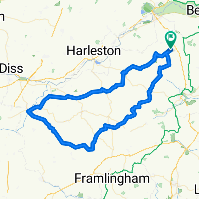
Waveney Sprint Tri bike route
A cycling route starting in Bungay, England, United Kingdom.
Overview
About this route
Bungay pool - Flixton - the saints - A144 - Bungay pool
- -:--
- Duration
- 18.9 km
- Distance
- 63 m
- Ascent
- 60 m
- Descent
- ---
- Avg. speed
- 46 m
- Max. altitude

Route quality
Waytypes & surfaces along the route
Waytypes
Quiet road
9.5 km
(50 %)
Busy road
8.7 km
(46 %)
Surfaces
Paved
2 km
(11 %)
Asphalt
2 km
(11 %)
Undefined
16.9 km
(89 %)
Continue with Bikemap
Use, edit, or download this cycling route
You would like to ride Waveney Sprint Tri bike route or customize it for your own trip? Here is what you can do with this Bikemap route:
Free features
- Save this route as favorite or in collections
- Copy & plan your own version of this route
- Sync your route with Garmin or Wahoo
Premium features
Free trial for 3 days, or one-time payment. More about Bikemap Premium.
- Navigate this route on iOS & Android
- Export a GPX / KML file of this route
- Create your custom printout (try it for free)
- Download this route for offline navigation
Discover more Premium features.
Get Bikemap PremiumFrom our community
Other popular routes starting in Bungay
 Fire Station, Hillside Road W, Bungay to 55 Flixton Road, Bungay
- Distance
- 5 km
- Ascent
- 36 m
- Descent
- 40 m
- Location
- Bungay, England, United Kingdom
 Out to Eye and back
- Distance
- 69.8 km
- Ascent
- 129 m
- Descent
- 129 m
- Location
- Bungay, England, United Kingdom
 BB Figure 8
- Distance
- 54.5 km
- Ascent
- 156 m
- Descent
- 151 m
- Location
- Bungay, England, United Kingdom
 100 mile Parkinsons Ride
- Distance
- 165.2 km
- Ascent
- 306 m
- Descent
- 305 m
- Location
- Bungay, England, United Kingdom
 bungay loop1
- Distance
- 82.6 km
- Ascent
- 315 m
- Descent
- 320 m
- Location
- Bungay, England, United Kingdom
 Bungay - Ellingham - Ditchingham Sprint
- Distance
- 10.2 km
- Ascent
- 14 m
- Descent
- 14 m
- Location
- Bungay, England, United Kingdom
 Bungay. Denton and Homersfield Round
- Distance
- 24.6 km
- Ascent
- 79 m
- Descent
- 78 m
- Location
- Bungay, England, United Kingdom
 Middle Road to Middle Road
- Distance
- 22.7 km
- Ascent
- 132 m
- Descent
- 136 m
- Location
- Bungay, England, United Kingdom
Open it in the app