

沖繩_Day 1
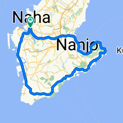
A cycling route starting in Naha, Okinawa, Japan.
Overview
About this route
- -:--
- Duration
- 53.9 km
- Distance
- 239 m
- Ascent
- 246 m
- Descent
- ---
- Avg. speed
- ---
- Max. altitude
Continue with Bikemap
Use, edit, or download this cycling route
You would like to ride 沖繩_Day 1 or customize it for your own trip? Here is what you can do with this Bikemap route:
Free features
- Save this route as favorite or in collections
- Copy & plan your own version of this route
- Sync your route with Garmin or Wahoo
Premium features
Free trial for 3 days, or one-time payment. More about Bikemap Premium.
- Navigate this route on iOS & Android
- Export a GPX / KML file of this route
- Create your custom printout (try it for free)
- Download this route for offline navigation
Discover more Premium features.
Get Bikemap PremiumFrom our community
Other popular routes starting in Naha
 2016 OKINAWA Trip DAY 4
- Distance
- 53.1 km
- Ascent
- 471 m
- Descent
- 472 m
- Location
- Naha, Okinawa, Japan
 Okinawa Cycling Trip Day Five
- Distance
- 60.6 km
- Ascent
- 267 m
- Descent
- 268 m
- Location
- Naha, Okinawa, Japan
 Project L&P, Okinawa 2010
- Distance
- 208.2 km
- Ascent
- 619 m
- Descent
- 619 m
- Location
- Naha, Okinawa, Japan
 jl04-Okinawa_south_round
- Distance
- 181.9 km
- Ascent
- 391 m
- Descent
- 391 m
- Location
- Naha, Okinawa, Japan
 沖繩_Day 1
- Distance
- 53.9 km
- Ascent
- 239 m
- Descent
- 246 m
- Location
- Naha, Okinawa, Japan
 沖繩2017_WHOLE
- Distance
- 486.3 km
- Ascent
- 1,054 m
- Descent
- 1,056 m
- Location
- Naha, Okinawa, Japan
 沖繩環島 Day 1
- Distance
- 82.7 km
- Ascent
- 348 m
- Descent
- 321 m
- Location
- Naha, Okinawa, Japan
 Okinawa
- Distance
- 97.8 km
- Ascent
- 285 m
- Descent
- 283 m
- Location
- Naha, Okinawa, Japan
Open it in the app