Schweiz - Atlantik; 10. Etappe Confolens (Camping Municipal) - Bourg Charante (Camping)
A cycling route starting in Confolens, Aquitaine-Limousin-Poitou-Charentes, France.
Overview
About this route
von <div class="cards-entity-title cards-strong cards-text-truncate-and-wrap"> <span>Terrain de Camping Municipal des Ribières</span></div> <div class="cards-text-truncate-and-wrap"> <span>21 Avenue de Saint-Germain</span></div> <div class="cards-text-truncate-and-wrap"> <span>16500 Confolens</span></div>
nach camping municipal<br /> <span>16200 </span>Bourg Charante - -:--
- Duration
- 108.7 km
- Distance
- 734 m
- Ascent
- 828 m
- Descent
- ---
- Avg. speed
- 222 m
- Avg. speed
Route quality
Waytypes & surfaces along the route
Waytypes
Busy road
71.3 km
(66 %)
Road
21.1 km
(19 %)
Surfaces
Paved
27.6 km
(25 %)
Unpaved
0.9 km
(<1 %)
Asphalt
26.7 km
(25 %)
Gravel
0.9 km
(<1 %)
Continue with Bikemap
Use, edit, or download this cycling route
You would like to ride Schweiz - Atlantik; 10. Etappe Confolens (Camping Municipal) - Bourg Charante (Camping) or customize it for your own trip? Here is what you can do with this Bikemap route:
Free features
- Save this route as favorite or in collections
- Copy & plan your own version of this route
- Sync your route with Garmin or Wahoo
Premium features
Free trial for 3 days, or one-time payment. More about Bikemap Premium.
- Navigate this route on iOS & Android
- Export a GPX / KML file of this route
- Create your custom printout (try it for free)
- Download this route for offline navigation
Discover more Premium features.
Get Bikemap PremiumFrom our community
Other popular routes starting in Confolens
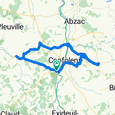
- Confolens to Augignac
- Distance
- 65.7 km
- Ascent
- 514 m
- Descent
- 369 m
- Location
- Confolens, Aquitaine-Limousin-Poitou-Charentes, France
- Confolens to Etagnac longer
- Distance
- 76.8 km
- Ascent
- 991 m
- Descent
- 986 m
- Location
- Confolens, Aquitaine-Limousin-Poitou-Charentes, France
- Confolens to La Chabroulie, near Saint-Mathieu
- Distance
- 55.2 km
- Ascent
- 519 m
- Descent
- 389 m
- Location
- Confolens, Aquitaine-Limousin-Poitou-Charentes, France
- Schweiz - Atlantik; 10. Etappe Confolens (Camping Municipal) - Bourg Charante (Camping)
- Distance
- 108.7 km
- Ascent
- 734 m
- Descent
- 828 m
- Location
- Confolens, Aquitaine-Limousin-Poitou-Charentes, France
- Confolence to Civray
- Distance
- 88.5 km
- Ascent
- 837 m
- Descent
- 841 m
- Location
- Confolens, Aquitaine-Limousin-Poitou-Charentes, France
- Confolens to Pressac
- Distance
- 50.2 km
- Ascent
- 447 m
- Descent
- 455 m
- Location
- Confolens, Aquitaine-Limousin-Poitou-Charentes, France
- De Confolens à D160, Pressignac
- Distance
- 31.3 km
- Ascent
- 423 m
- Descent
- 335 m
- Location
- Confolens, Aquitaine-Limousin-Poitou-Charentes, France
- 9 bis Rue Fontaine de Guimard, Confolens to 11 Rue Fontaine de Guimard, Confolens
- Distance
- 61 km
- Ascent
- 1,018 m
- Descent
- 1,017 m
- Location
- Confolens, Aquitaine-Limousin-Poitou-Charentes, France
Open it in the app