

W Dolomity (12 dni) 2002r
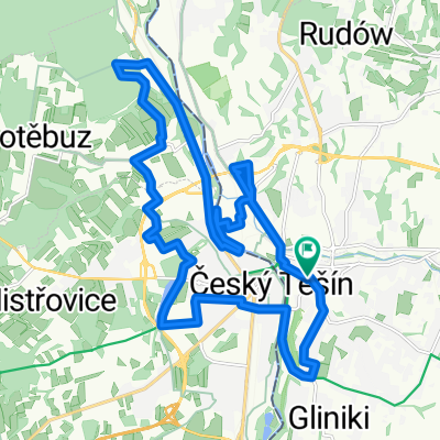
A cycling route starting in Cieszyn, Silesian Voivodeship, Poland.
Overview
About this route
Beautiful :) The Dolomites are amazing, and so are the Austrian Alps.
- -:--
- Duration
- 2,273.5 km
- Distance
- 34,645 m
- Ascent
- 34,441 m
- Descent
- ---
- Avg. speed
- 2,507 m
- Max. altitude

Route quality
Waytypes & surfaces along the route
Waytypes
Quiet road
295.6 km
(13 %)
Road
272.8 km
(12 %)
Surfaces
Paved
1,523.3 km
(67 %)
Unpaved
90.9 km
(4 %)
Asphalt
1,500.5 km
(66 %)
Gravel
45.5 km
(2 %)
Route highlights
Points of interest along the route
 2002r\"")
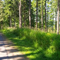
Photo after 289.8 km
 2002r\"")
Photo after 359.2 km
 2002r\"")
Point of interest after 398.9 km
ARBESBACH 903 mnpm
 2002r\"")
Photo after 669.3 km
Point of interest after 682.8 km
STEINPASS 613 mnpm
Point of interest after 723.9 km
PASS STRUB 704 mnpm
 2002r\"")
Photo after 757.9 km
 2002r\"")
Photo after 763.4 km
Point of interest after 914.4 km
KUHTAI-SATTEL 2020 mnpm
Point of interest after 1,008.7 km
HICHGURGL MAUTSTELLE 2178 mnpm
Point of interest after 1,015.4 km
TIMMELSJOCH 2509 mnpm
 2002r\"")
Point of interest after 1,063.5 km
JAUFENPASS 2094 mnpm
 2002r\"")
Photo after 1,064.4 km
 2002r\"")
Photo after 1,085.7 km
 2002r\"")
Photo after 1,252.6 km
Point of interest after 1,258.8 km
SELLAJOCH 2244 mnpm
 2002r\"")
Point of interest after 1,270.1 km
PORDOI 2239 mnpm
 2002r\"")
Photo after 1,274.2 km
 2002r\"")
Photo after 1,275.2 km
 2002r\"")
Photo after 1,276.2 km
 2002r\"")
Photo after 1,277.2 km
 2002r\"")
Point of interest after 1,278.4 km
PORTA VESCOVO 2511 mnpm rif. Luigi Gorza
 2002r\"")
Photo after 1,282.6 km
 2002r\"")
Photo after 1,293.4 km
 2002r\"")
Photo after 1,300.6 km
 2002r\"")
Photo after 1,305.9 km
 2002r\"")
Point of interest after 1,306.1 km
VALPAROLA 2197 mnpm
 2002r\"")
Point of interest after 1,308.3 km
FALZAREGO 2105 mnpm
 2002r\"")
Photo after 1,317.5 km
 2002r\"")
Photo after 1,318.5 km
Point of interest after 1,319.2 km
NOVOLAU 2413 mnpm
 2002r\"")
Photo after 1,320 km
 2002r\"")
Point of interest after 1,324.3 km
GIAU 2236 mnpm
Point of interest after 1,353 km
CIMA BANCHE 1530 mnpm
 2002r\"")
Photo after 1,398.7 km
Point of interest after 1,459.8 km
ISELSBERG 1204 mnpm
 2002r\"")
Photo after 1,473.5 km
 2002r\"")
Photo after 1,482.2 km
 2002r\"")
Point of interest after 1,496.9 km
HOCHTOR 2504 mnpm
 2002r\"")
Photo after 1,497.2 km
 2002r\"")
Photo after 1,501.3 km
 2002r\"")
Photo after 1,501.5 km
 2002r\"")
Photo after 1,502.8 km
 2002r\"")
Point of interest after 1,504.3 km
EDELWEISS-SPITZE 2571 mnpm
Point of interest after 1,600 km
WAGRAINER HOHE 933 mnpm
 2002r\"")
Photo after 1,700 km
Point of interest after 1,715.4 km
BUCHAUER SATTEL 861 mnpm
 2002r\"")
Photo after 1,883.2 km
 2002r\"")
Photo after 2,006.9 km
 2002r\"")
Photo after 2,007 km
 2002r\"")
Photo after 2,024.3 km
Continue with Bikemap
Use, edit, or download this cycling route
You would like to ride W Dolomity (12 dni) 2002r or customize it for your own trip? Here is what you can do with this Bikemap route:
Free features
- Save this route as favorite or in collections
- Copy & plan your own version of this route
- Split it into stages to create a multi-day tour
- Sync your route with Garmin or Wahoo
Premium features
Free trial for 3 days, or one-time payment. More about Bikemap Premium.
- Navigate this route on iOS & Android
- Export a GPX / KML file of this route
- Create your custom printout (try it for free)
- Download this route for offline navigation
Discover more Premium features.
Get Bikemap PremiumFrom our community
Other popular routes starting in Cieszyn
 Białogród i słupy graniczne
- Distance
- 80.7 km
- Ascent
- 273 m
- Descent
- 273 m
- Location
- Cieszyn, Silesian Voivodeship, Poland
 W Dolomity (12 dni) 2002r
- Distance
- 2,273.5 km
- Ascent
- 34,645 m
- Descent
- 34,441 m
- Location
- Cieszyn, Silesian Voivodeship, Poland
 Cieszyn - Czeski Cieszyn "Bunkry"
- Distance
- 22.3 km
- Ascent
- 172 m
- Descent
- 173 m
- Location
- Cieszyn, Silesian Voivodeship, Poland
 Hrčava
- Distance
- 103.3 km
- Ascent
- 692 m
- Descent
- 691 m
- Location
- Cieszyn, Silesian Voivodeship, Poland
 Kubalonka - inaczej, trudniej !
- Distance
- 88.1 km
- Ascent
- 714 m
- Descent
- 714 m
- Location
- Cieszyn, Silesian Voivodeship, Poland
 Cieszyn-Dziegielow-Goleszow-Puncow-Cieszyn
- Distance
- 24.3 km
- Ascent
- 271 m
- Descent
- 276 m
- Location
- Cieszyn, Silesian Voivodeship, Poland
 Wokół Łysej Góry
- Distance
- 110.8 km
- Ascent
- 1,000 m
- Descent
- 1,000 m
- Location
- Cieszyn, Silesian Voivodeship, Poland
 Między Ostrawicą i Łucyną
- Distance
- 69.3 km
- Ascent
- 555 m
- Descent
- 555 m
- Location
- Cieszyn, Silesian Voivodeship, Poland
Open it in the app