

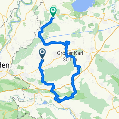
Steinhuder Meer
A cycling route starting in Helpsen, Lower Saxony, Germany.
Overview
About this route
- -:--
- Duration
- 80.4 km
- Distance
- 156 m
- Ascent
- 156 m
- Descent
- ---
- Avg. speed
- ---
- Max. altitude
Route quality
Waytypes & surfaces along the route
Waytypes
Track
23.3 km
(29 %)
Quiet road
20.1 km
(25 %)
Surfaces
Paved
50.6 km
(63 %)
Unpaved
20.1 km
(25 %)
Asphalt
46.6 km
(58 %)
Gravel
11.3 km
(14 %)
Continue with Bikemap
Use, edit, or download this cycling route
You would like to ride Steinhuder Meer or customize it for your own trip? Here is what you can do with this Bikemap route:
Free features
- Save this route as favorite or in collections
- Copy & plan your own version of this route
- Split it into stages to create a multi-day tour
- Sync your route with Garmin or Wahoo
Premium features
Free trial for 3 days, or one-time payment. More about Bikemap Premium.
- Navigate this route on iOS & Android
- Export a GPX / KML file of this route
- Create your custom printout (try it for free)
- Download this route for offline navigation
Discover more Premium features.
Get Bikemap PremiumFrom our community
Other popular routes starting in Helpsen
 Akazienweg 28, Seggebruch nach Rotdornweg 2, Seggebruch
- Distance
- 22.2 km
- Ascent
- 41 m
- Descent
- 38 m
- Location
- Helpsen, Lower Saxony, Germany
 Kirchhorsten - Hannover 71
- Distance
- 71.2 km
- Ascent
- 679 m
- Descent
- 679 m
- Location
- Helpsen, Lower Saxony, Germany
 Eisdiele Lahde
- Distance
- 19.5 km
- Ascent
- 93 m
- Descent
- 113 m
- Location
- Helpsen, Lower Saxony, Germany
 Gerade Fahrt in
- Distance
- 37 km
- Ascent
- 32 m
- Descent
- 36 m
- Location
- Helpsen, Lower Saxony, Germany
 Leichte Fahrt
- Distance
- 3.9 km
- Ascent
- 3 m
- Descent
- 50 m
- Location
- Helpsen, Lower Saxony, Germany
 Helpsen nach Hagenburg
- Distance
- 25.7 km
- Ascent
- 124 m
- Descent
- 138 m
- Location
- Helpsen, Lower Saxony, Germany
 Auf dem Bergkrug 14, Hespe nach Auf dem Bergkrug 14, Hespe
- Distance
- 13.9 km
- Ascent
- 6 m
- Descent
- 6 m
- Location
- Helpsen, Lower Saxony, Germany
 Enzer Straße, Helpsen nach Bahnhofstraße, Rehburg-Loccum
- Distance
- 76.3 km
- Ascent
- 901 m
- Descent
- 886 m
- Location
- Helpsen, Lower Saxony, Germany
Open it in the app