

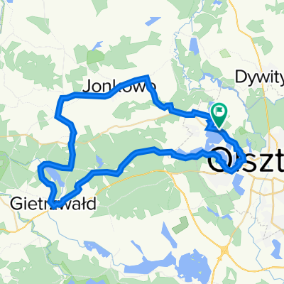
Mazury trip
A cycling route starting in Olsztyn, Warmian-Masurian Voivodeship, Poland.
Overview
About this route
- -:--
- Duration
- 208.5 km
- Distance
- 289 m
- Ascent
- 304 m
- Descent
- ---
- Avg. speed
- ---
- Max. altitude

Route quality
Waytypes & surfaces along the route
Waytypes
Quiet road
62.6 km
(30 %)
Road
27.1 km
(13 %)
Surfaces
Paved
127.2 km
(61 %)
Unpaved
37.5 km
(18 %)
Asphalt
118.9 km
(57 %)
Gravel
12.5 km
(6 %)
Route highlights
Points of interest along the route

Accommodation after 9.7 km
CAMPING 1DZIEN

Accommodation after 97.9 km
CAMP DAY 2
Continue with Bikemap
Use, edit, or download this cycling route
You would like to ride Mazury trip or customize it for your own trip? Here is what you can do with this Bikemap route:
Free features
- Save this route as favorite or in collections
- Copy & plan your own version of this route
- Split it into stages to create a multi-day tour
- Sync your route with Garmin or Wahoo
Premium features
Free trial for 3 days, or one-time payment. More about Bikemap Premium.
- Navigate this route on iOS & Android
- Export a GPX / KML file of this route
- Create your custom printout (try it for free)
- Download this route for offline navigation
Discover more Premium features.
Get Bikemap PremiumFrom our community
Other popular routes starting in Olsztyn
 Silice
- Distance
- 24.7 km
- Ascent
- 108 m
- Descent
- 111 m
- Location
- Olsztyn, Warmian-Masurian Voivodeship, Poland
 Olsztyn-Ukiel
- Distance
- 22.6 km
- Ascent
- 220 m
- Descent
- 222 m
- Location
- Olsztyn, Warmian-Masurian Voivodeship, Poland
 las miejski 10 km
- Distance
- 10.6 km
- Ascent
- 159 m
- Descent
- 157 m
- Location
- Olsztyn, Warmian-Masurian Voivodeship, Poland
 Olsztyn i J Wulpinskie
- Distance
- 50.7 km
- Ascent
- 226 m
- Descent
- 226 m
- Location
- Olsztyn, Warmian-Masurian Voivodeship, Poland
 błądzenie za dajtkami
- Distance
- 27.4 km
- Ascent
- 211 m
- Descent
- 207 m
- Location
- Olsztyn, Warmian-Masurian Voivodeship, Poland
 Olsztyn
- Distance
- 48.4 km
- Ascent
- 275 m
- Descent
- 275 m
- Location
- Olsztyn, Warmian-Masurian Voivodeship, Poland
 Las miejski - Wadag
- Distance
- 14.5 km
- Ascent
- 172 m
- Descent
- 189 m
- Location
- Olsztyn, Warmian-Masurian Voivodeship, Poland
 Do Gietrzwaldu (dookola J Ukiel)
- Distance
- 49.8 km
- Ascent
- 298 m
- Descent
- 299 m
- Location
- Olsztyn, Warmian-Masurian Voivodeship, Poland
Open it in the app