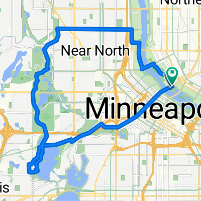
Loring Park, Minneapolis to Yale Pl, Minneapolis
- 31.4 km
- 180 m
- 181 m
- Minneapolis, Minnesota, United States
A cycling route starting in Minneapolis, Minnesota, United States.
Overview
Head south on Bryant to the Greenway entrance ramp which is just south of 28th St. Take a left onto the Greenway, and head east. When you reach 28th Street/Hiawatha, take the bike bridge over Hiawatha. (Note: before you enter onto the bridge, you must cross 28th where cross traffic does not have a stop sign.) Once over the bridge, take a left to head north along the trail (alongside the Hiawathat Light Rail). When you reach the Cedar Riverside Station, take a right onto 15th, and a right onto 6th St. Take 6th St to 20th Ave, where you take a left and head into campus. 20th will end at 4th St, where you take a right, and a quick left onto the campus bike lane. Follow that north to the bike/pedestrian bridge (Washington) and follow over the River. Once on the East bank, veer right, and either walk your bike on the sidewalk to Walnut St or bike on Washington to Walnut St (about 2.5 blocks). Right onto Walnut down to destination on Delaware.
created this 17 years ago
Continue with Bikemap
You would like to ride B2B00210 55404 > 55455 via Greenway, Hiawatha LRT trail or customize it for your own trip? Here is what you can do with this Bikemap route:
Free trial for 3 days, or one-time payment. More about Bikemap Premium.
Discover more Premium features.
Get Bikemap PremiumFrom our community
Open it in the app