

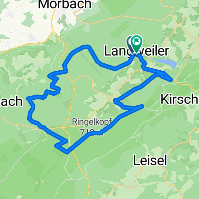
langweiler morbach allenbach sensweiler langweiler
A cycling route starting in Langweiler, Rhineland-Palatinate, Germany.
Overview
About this route
nice ründsche
- -:--
- Duration
- 22.7 km
- Distance
- 494 m
- Ascent
- 493 m
- Descent
- ---
- Avg. speed
- ---
- Max. altitude
Route quality
Waytypes & surfaces along the route
Waytypes
Road
4.8 km
(21 %)
Track
2 km
(9 %)
Surfaces
Paved
17.9 km
(79 %)
Unpaved
1.4 km
(6 %)
Asphalt
17.9 km
(79 %)
Gravel
0.7 km
(3 %)
Continue with Bikemap
Use, edit, or download this cycling route
You would like to ride langweiler morbach allenbach sensweiler langweiler or customize it for your own trip? Here is what you can do with this Bikemap route:
Free features
- Save this route as favorite or in collections
- Copy & plan your own version of this route
- Sync your route with Garmin or Wahoo
Premium features
Free trial for 3 days, or one-time payment. More about Bikemap Premium.
- Navigate this route on iOS & Android
- Export a GPX / KML file of this route
- Create your custom printout (try it for free)
- Download this route for offline navigation
Discover more Premium features.
Get Bikemap PremiumFrom our community
Other popular routes starting in Langweiler
 Langweiler 2020 / 1
- Distance
- 46.4 km
- Ascent
- 765 m
- Descent
- 748 m
- Location
- Langweiler, Rhineland-Palatinate, Germany
 Lang 01a FR aH 31KM 400HM
- Distance
- 33.9 km
- Ascent
- 640 m
- Descent
- 650 m
- Location
- Langweiler, Rhineland-Palatinate, Germany
 Langweiler_2020/2
- Distance
- 28.2 km
- Ascent
- 551 m
- Descent
- 518 m
- Location
- Langweiler, Rhineland-Palatinate, Germany
 Langweiler 32
- Distance
- 31.3 km
- Ascent
- 517 m
- Descent
- 518 m
- Location
- Langweiler, Rhineland-Palatinate, Germany
 langweiler morbach allenbach sensweiler langweiler
- Distance
- 22.7 km
- Ascent
- 494 m
- Descent
- 493 m
- Location
- Langweiler, Rhineland-Palatinate, Germany
 langweiler 2017
- Distance
- 41.7 km
- Ascent
- 778 m
- Descent
- 778 m
- Location
- Langweiler, Rhineland-Palatinate, Germany
 LANG 02 aH Osten Langweiler
- Distance
- 28.2 km
- Ascent
- 738 m
- Descent
- 741 m
- Location
- Langweiler, Rhineland-Palatinate, Germany
 Naheland-Touristik GmbH, www.naheland.net - Naheland-Touristik GmbH
- Distance
- 13.3 km
- Ascent
- 263 m
- Descent
- 262 m
- Location
- Langweiler, Rhineland-Palatinate, Germany
Open it in the app