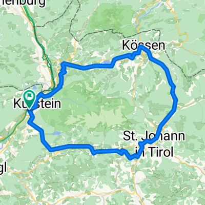
Reintaler1 2010
A cycling route starting in Kufstein, Tyrol, Austria.
Overview
About this route
Von Kufstein entlang des Inn`s nach Bichlwang,über die Innbrücke nach Langkampfen weiter nach Angath, Wörgl den Radweg nach Kundl/Breitenbach a.I. bis nach Kramsach (hier ist der Wendepunkt)nun die leichte Steigung hoch zu den Reintalerseen. Der verkehrsarmen Landesstrasse folgend bis nach Breitenbach. Nun wieder den Radweg zurück nach Kufstein.
- -:--
- Duration
- 64.7 km
- Distance
- 174 m
- Ascent
- 177 m
- Descent
- ---
- Avg. speed
- 581 m
- Max. altitude
Route quality
Waytypes & surfaces along the route
Waytypes
Quiet road
20.7 km
(32 %)
Track
19.4 km
(30 %)
Surfaces
Paved
55.6 km
(86 %)
Unpaved
0.6 km
(1 %)
Asphalt
55.6 km
(86 %)
Gravel
0.6 km
(1 %)
Undefined
8.4 km
(13 %)
Continue with Bikemap
Use, edit, or download this cycling route
You would like to ride Reintaler1 2010 or customize it for your own trip? Here is what you can do with this Bikemap route:
Free features
- Save this route as favorite or in collections
- Copy & plan your own version of this route
- Sync your route with Garmin or Wahoo
Premium features
Free trial for 3 days, or one-time payment. More about Bikemap Premium.
- Navigate this route on iOS & Android
- Export a GPX / KML file of this route
- Create your custom printout (try it for free)
- Download this route for offline navigation
Discover more Premium features.
Get Bikemap PremiumFrom our community
Other popular routes starting in Kufstein
02-rund_um_die_salve_und_den_kaiser_96896450- Distance
- 95.3 km
- Ascent
- 765 m
- Descent
- 768 m
- Location
- Kufstein, Tyrol, Austria
From Eben am Achensee to Innsbruck- Distance
- 83 km
- Ascent
- 315 m
- Descent
- 229 m
- Location
- Kufstein, Tyrol, Austria
Vorderer Sonnberg Kiefer Ku- Distance
- 36.9 km
- Ascent
- 962 m
- Descent
- 962 m
- Location
- Kufstein, Tyrol, Austria
Kufstein Tatzelwurm- Distance
- 44.2 km
- Ascent
- 664 m
- Descent
- 664 m
- Location
- Kufstein, Tyrol, Austria
3.1_Poelvenradrunde- Distance
- 38.2 km
- Ascent
- 715 m
- Descent
- 715 m
- Location
- Kufstein, Tyrol, Austria
kaiserradrunde_138284948- Distance
- 85.8 km
- Ascent
- 816 m
- Descent
- 813 m
- Location
- Kufstein, Tyrol, Austria
Der Grenz-Rochen- Distance
- 30.3 km
- Ascent
- 319 m
- Descent
- 318 m
- Location
- Kufstein, Tyrol, Austria
5.1_Kaiserlift - ab Bergstation- Distance
- 15 km
- Ascent
- 351 m
- Descent
- 1,127 m
- Location
- Kufstein, Tyrol, Austria
Open it in the app


