

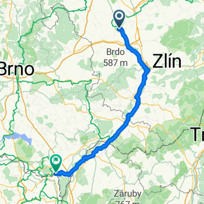
Výlet po Zástudánčí
A cycling route starting in Chropyně, Zlín, Czechia.
Overview
About this route
Round trip - a beautiful ride on the singing forest paths in the area of the underground gas storage.
- -:--
- Duration
- 7.2 km
- Distance
- 46 m
- Ascent
- 46 m
- Descent
- ---
- Avg. speed
- ---
- Max. altitude
Route quality
Waytypes & surfaces along the route
Waytypes
Track
5.5 km
(77 %)
Quiet road
1.6 km
(23 %)
Surfaces
Paved
6.7 km
(94 %)
Unpaved
0.4 km
(6 %)
Asphalt
6.2 km
(86 %)
Paved (undefined)
0.6 km
(8 %)
Continue with Bikemap
Use, edit, or download this cycling route
You would like to ride Výlet po Zástudánčí or customize it for your own trip? Here is what you can do with this Bikemap route:
Free features
- Save this route as favorite or in collections
- Copy & plan your own version of this route
- Sync your route with Garmin or Wahoo
Premium features
Free trial for 3 days, or one-time payment. More about Bikemap Premium.
- Navigate this route on iOS & Android
- Export a GPX / KML file of this route
- Create your custom printout (try it for free)
- Download this route for offline navigation
Discover more Premium features.
Get Bikemap PremiumFrom our community
Other popular routes starting in Chropyně
 Výlet po Zástudánčí
- Distance
- 7.2 km
- Ascent
- 46 m
- Descent
- 46 m
- Location
- Chropyně, Zlín, Czechia
 Moravia 2014 - part III. - 59km
- Distance
- 59.6 km
- Ascent
- 124 m
- Descent
- 86 m
- Location
- Chropyně, Zlín, Czechia
 ❤️❤️❤️
- Distance
- 25.7 km
- Ascent
- 76 m
- Descent
- 24 m
- Location
- Chropyně, Zlín, Czechia
 31km chr_hul_kro_otr
- Distance
- 31.1 km
- Ascent
- 47 m
- Descent
- 58 m
- Location
- Chropyně, Zlín, Czechia
 Chropyně
- Distance
- 52 km
- Ascent
- 75 m
- Descent
- 72 m
- Location
- Chropyně, Zlín, Czechia
 Karla Hynka Máchy do Karla Hynka Máchy
- Distance
- 48.4 km
- Ascent
- 231 m
- Descent
- 270 m
- Location
- Chropyně, Zlín, Czechia
 Chropyně - Břeclav
- Distance
- 121 km
- Ascent
- 280 m
- Descent
- 324 m
- Location
- Chropyně, Zlín, Czechia
 km km
km km- Distance
- 174.8 km
- Ascent
- 1,047 m
- Descent
- 1,030 m
- Location
- Chropyně, Zlín, Czechia
Open it in the app