
Lengthy bike tour from 15 sierpnia, 10:03
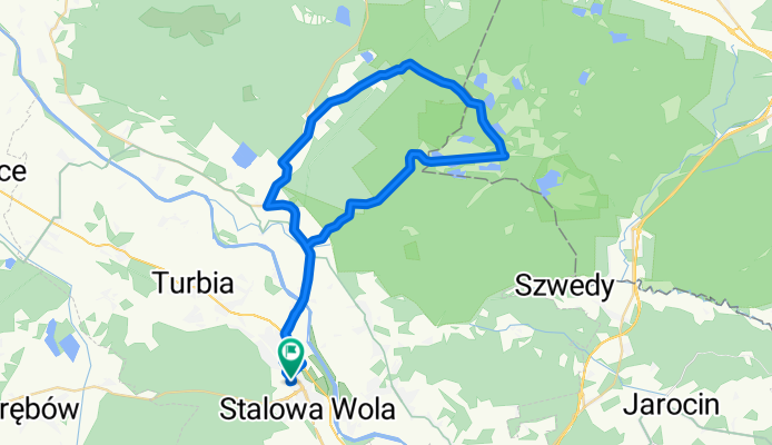
A cycling route starting in Stalowa Wola, Subcarpathian Voivodeship, Poland.
Overview
About this route
- 3 h 29 min
- Duration
- 49.3 km
- Distance
- 94 m
- Ascent
- 96 m
- Descent
- 14.2 km/h
- Avg. speed
- ---
- Max. altitude

Route photos

Route quality
Waytypes & surfaces along the route
Waytypes
Road
12.8 km
(26 %)
Path
8.9 km
(18 %)
Surfaces
Paved
14.8 km
(30 %)
Unpaved
7.4 km
(15 %)
Asphalt
14.3 km
(29 %)
Sand
4.4 km
(9 %)
Continue with Bikemap
Use, edit, or download this cycling route
You would like to ride Lengthy bike tour from 15 sierpnia, 10:03 or customize it for your own trip? Here is what you can do with this Bikemap route:
Free features
- Save this route as favorite or in collections
- Copy & plan your own version of this route
- Sync your route with Garmin or Wahoo
Premium features
Free trial for 3 days, or one-time payment. More about Bikemap Premium.
- Navigate this route on iOS & Android
- Export a GPX / KML file of this route
- Create your custom printout (try it for free)
- Download this route for offline navigation
Discover more Premium features.
Get Bikemap PremiumFrom our community
Other popular routes starting in Stalowa Wola
 BIKE.TOUR.2014 ROZTOCZE
- Distance
- 236.3 km
- Ascent
- 329 m
- Descent
- 323 m
- Location
- Stalowa Wola, Subcarpathian Voivodeship, Poland
 Rowerowa trasa do PxM 2011/2012
- Distance
- 44.8 km
- Ascent
- 57 m
- Descent
- 57 m
- Location
- Stalowa Wola, Subcarpathian Voivodeship, Poland
 Krótki trip po lesie
- Distance
- 55.3 km
- Ascent
- 177 m
- Descent
- 177 m
- Location
- Stalowa Wola, Subcarpathian Voivodeship, Poland
 Wyśmienita i wszechstronna trasa na wierczorne: bieganie/jazdę na rolkach/jazdę na rowerze.
- Distance
- 6.4 km
- Ascent
- 24 m
- Descent
- 26 m
- Location
- Stalowa Wola, Subcarpathian Voivodeship, Poland
 Lekki powiem wiosny
- Distance
- 36.2 km
- Ascent
- 35 m
- Descent
- 32 m
- Location
- Stalowa Wola, Subcarpathian Voivodeship, Poland
 Lengthy bike tour from 15 sierpnia, 10:03
- Distance
- 49.3 km
- Ascent
- 94 m
- Descent
- 96 m
- Location
- Stalowa Wola, Subcarpathian Voivodeship, Poland
 Łącznik Greenvelo przez Lasy Państwowe
- Distance
- 12.7 km
- Ascent
- 33 m
- Descent
- 30 m
- Location
- Stalowa Wola, Subcarpathian Voivodeship, Poland
 104 (28/16) Stalowa Wola-Bojanów-Brzóza Król.-Żołynia-Mikulice-Kańczuga
- Distance
- 103.7 km
- Ascent
- 255 m
- Descent
- 218 m
- Location
- Stalowa Wola, Subcarpathian Voivodeship, Poland
Open it in the app