

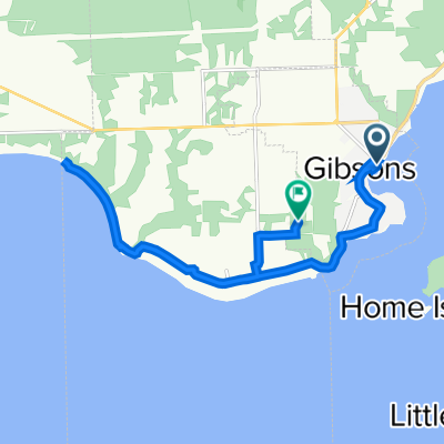
Sunshine Coast - Gibsons to Egmont
A cycling route starting in Gibsons, British Columbia, Canada.
Overview
About this route
Vancouver - Horshoe Bay Ferry Terminal - [ferry] - Langdale Ferry Terminal - Gibsons - Roberts Creek - Sechelt - Halfmoon Bay - Pender Harbour - Egmont
- -:--
- Duration
- 93.4 km
- Distance
- 902 m
- Ascent
- 888 m
- Descent
- ---
- Avg. speed
- ---
- Max. altitude

Route quality
Waytypes & surfaces along the route
Waytypes
Busy road
50.5 km
(54 %)
Road
31.5 km
(34 %)
Surfaces
Paved
59.9 km
(64 %)
Unpaved
0.1 km
(<1 %)
Paved (undefined)
45.5 km
(49 %)
Asphalt
14.3 km
(15 %)
Continue with Bikemap
Use, edit, or download this cycling route
You would like to ride Sunshine Coast - Gibsons to Egmont or customize it for your own trip? Here is what you can do with this Bikemap route:
Free features
- Save this route as favorite or in collections
- Copy & plan your own version of this route
- Split it into stages to create a multi-day tour
- Sync your route with Garmin or Wahoo
Premium features
Free trial for 3 days, or one-time payment. More about Bikemap Premium.
- Navigate this route on iOS & Android
- Export a GPX / KML file of this route
- Create your custom printout (try it for free)
- Download this route for offline navigation
Discover more Premium features.
Get Bikemap PremiumFrom our community
Other popular routes starting in Gibsons
 Langdale > Smuggler's Cove
- Distance
- 108.1 km
- Ascent
- 837 m
- Descent
- 837 m
- Location
- Gibsons, British Columbia, Canada
 Sunshine Coast (Langdale to Sechelt)
- Distance
- 37.4 km
- Ascent
- 532 m
- Descent
- 523 m
- Location
- Gibsons, British Columbia, Canada
 Langdale to Davis Bay
- Distance
- 22.5 km
- Ascent
- 417 m
- Descent
- 420 m
- Location
- Gibsons, British Columbia, Canada
 Day1.2 Langdale to Earls Cove
- Distance
- 81.7 km
- Ascent
- ---
- Descent
- ---
- Location
- Gibsons, British Columbia, Canada
 Gibsons Petro-Canada to Wheatberries in Sechelt
- Distance
- 17 km
- Ascent
- 104 m
- Descent
- 232 m
- Location
- Gibsons, British Columbia, Canada
 643 School Rd, Gibsons to 932 Chaster Rd, Gibsons
- Distance
- 12.9 km
- Ascent
- 306 m
- Descent
- 217 m
- Location
- Gibsons, British Columbia, Canada
 sunshine coast (Langdale to Sechelt)
- Distance
- 28.7 km
- Ascent
- 413 m
- Descent
- 404 m
- Location
- Gibsons, British Columbia, Canada
 Recovered Route
- Distance
- 12.3 km
- Ascent
- 312 m
- Descent
- 365 m
- Location
- Gibsons, British Columbia, Canada
Open it in the app