

Fuenfría y los Leones
A cycling route starting in Cercedilla, Madrid, Spain.
Overview
About this route
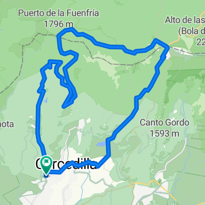
Ruta para bicicleta todo terreno partiendo de Cercedilla. Se sube al puerto de la Fuenfría y al Collado Marichiva, desde donde se baja por la provincia de Segovia, a través de la cuenca del río Moros, para volver a entrar a Madrid por el Alto del León.
- -:--
- Duration
- 36.3 km
- Distance
- 846 m
- Ascent
- 847 m
- Descent
- ---
- Avg. speed
- ---
- Avg. speed

Route quality
Waytypes & surfaces along the route
Waytypes
Track
25.6 km
(71 %)
Road
4.1 km
(11 %)
Surfaces
Paved
7 km
(19 %)
Unpaved
27 km
(74 %)
Ground
17.2 km
(48 %)
Gravel
9 km
(25 %)
Continue with Bikemap
Use, edit, or download this cycling route
You would like to ride Fuenfría y los Leones or customize it for your own trip? Here is what you can do with this Bikemap route:
Free features
- Save this route as favorite or in collections
- Copy & plan your own version of this route
- Sync your route with Garmin or Wahoo
Premium features
Free trial for 3 days, or one-time payment. More about Bikemap Premium.
- Navigate this route on iOS & Android
- Export a GPX / KML file of this route
- Create your custom printout (try it for free)
- Download this route for offline navigation
Discover more Premium features.
Get Bikemap PremiumFrom our community
Other popular routes starting in Cercedilla
 cercedilla - mirador del poeta - cercedilla
- Distance
- 18.4 km
- Ascent
- 612 m
- Descent
- 610 m
- Location
- Cercedilla, Madrid, Spain
 Cercedilla - Pto. Fuenfría - Pto. Navacerrada - Cercedilla
- Distance
- 28.9 km
- Ascent
- 800 m
- Descent
- 801 m
- Location
- Cercedilla, Madrid, Spain
 Cercedilla-Pto Leones
- Distance
- 41.7 km
- Ascent
- 844 m
- Descent
- 844 m
- Location
- Cercedilla, Madrid, Spain
 Fuenfría y los Leones
- Distance
- 36.3 km
- Ascent
- 846 m
- Descent
- 847 m
- Location
- Cercedilla, Madrid, Spain
 Los Tres Valles
- Distance
- 48.8 km
- Ascent
- 1,225 m
- Descent
- 1,225 m
- Location
- Cercedilla, Madrid, Spain
 Cercedilla- Pto.Fuenfría- Pto. Navacerrada- Alto Guarramillas (Bola del mundo)
- Distance
- 21.1 km
- Ascent
- 1,305 m
- Descent
- 236 m
- Location
- Cercedilla, Madrid, Spain
 Horizontal de la Fuenfria
- Distance
- 19.4 km
- Ascent
- 743 m
- Descent
- 264 m
- Location
- Cercedilla, Madrid, Spain
 CERCEDILLA-COSLADA
- Distance
- 85.5 km
- Ascent
- 314 m
- Descent
- 853 m
- Location
- Cercedilla, Madrid, Spain
Open it in the app