

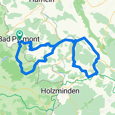
MTB - Bad Pyrmont Hohe Stolle- Grenzweg-Schlangenweg
A cycling route starting in Bad Pyrmont, Lower Saxony, Germany.
Overview
About this route
Start Parkplatz Friedensthal am Wald-HoheStolle -Weg befestigter u. unbefestigter Waldweg - interessanter Trail
- 1 h 59 min
- Duration
- 15.5 km
- Distance
- 353 m
- Ascent
- 342 m
- Descent
- 7.9 km/h
- Avg. speed
- ---
- Max. altitude

Route photos


Route highlights
Points of interest along the route
Point of interest after 6.2 km
Bank🚩
Accommodation after 8.6 km
Grenzweg Ende 🏴
Point of interest after 9.9 km
Spelunkenturm🏳
Continue with Bikemap
Use, edit, or download this cycling route
You would like to ride MTB - Bad Pyrmont Hohe Stolle- Grenzweg-Schlangenweg or customize it for your own trip? Here is what you can do with this Bikemap route:
Free features
- Save this route as favorite or in collections
- Copy & plan your own version of this route
- Sync your route with Garmin or Wahoo
Premium features
Free trial for 3 days, or one-time payment. More about Bikemap Premium.
- Navigate this route on iOS & Android
- Export a GPX / KML file of this route
- Create your custom printout (try it for free)
- Download this route for offline navigation
Discover more Premium features.
Get Bikemap PremiumFrom our community
Other popular routes starting in Bad Pyrmont
 Skinfit Tour 1 (Um die Hochebene)
- Distance
- 68.7 km
- Ascent
- 388 m
- Descent
- 398 m
- Location
- Bad Pyrmont, Lower Saxony, Germany
 21 km Bad Pyrmont Waldweg
- Distance
- 21.9 km
- Ascent
- 478 m
- Descent
- 483 m
- Location
- Bad Pyrmont, Lower Saxony, Germany
 MTB - Bad Pyrmont Hohe Stolle- Grenzweg-Schlangenweg
- Distance
- 15.5 km
- Ascent
- 353 m
- Descent
- 342 m
- Location
- Bad Pyrmont, Lower Saxony, Germany
 Runde um Bad Pyrmont
- Distance
- 31.5 km
- Ascent
- 489 m
- Descent
- 485 m
- Location
- Bad Pyrmont, Lower Saxony, Germany
 Bad Pyrmont-Ostwestfalenstraße-Köterberg
- Distance
- 86.1 km
- Ascent
- 757 m
- Descent
- 757 m
- Location
- Bad Pyrmont, Lower Saxony, Germany
 Bad Pyrmont-Rühler-Schweiz
- Distance
- 106.7 km
- Ascent
- 1,293 m
- Descent
- 1,239 m
- Location
- Bad Pyrmont, Lower Saxony, Germany
 Holzhausen-Meinte-Eschenbruch-Hagen-Holzhausen
- Distance
- 28.3 km
- Ascent
- 476 m
- Descent
- 471 m
- Location
- Bad Pyrmont, Lower Saxony, Germany
 Halbe Runde um Bad Pyrmont
- Distance
- 30.8 km
- Ascent
- 444 m
- Descent
- 443 m
- Location
- Bad Pyrmont, Lower Saxony, Germany
Open it in the app