

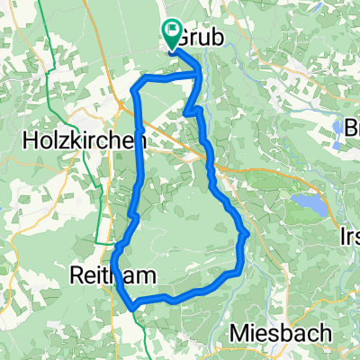
Kreuzstraße - Spitzing - Kreuzstraße
A cycling route starting in Valley, Bavaria, Germany.
Overview
About this route
- -:--
- Duration
- 103.6 km
- Distance
- 1,433 m
- Ascent
- 1,447 m
- Descent
- ---
- Avg. speed
- 1,138 m
- Max. altitude

Route quality
Waytypes & surfaces along the route
Waytypes
Quiet road
51.8 km
(50 %)
Road
18.6 km
(18 %)
Surfaces
Paved
94.3 km
(91 %)
Unpaved
4.1 km
(4 %)
Asphalt
94.3 km
(91 %)
Gravel
3.1 km
(3 %)
Continue with Bikemap
Use, edit, or download this cycling route
You would like to ride Kreuzstraße - Spitzing - Kreuzstraße or customize it for your own trip? Here is what you can do with this Bikemap route:
Free features
- Save this route as favorite or in collections
- Copy & plan your own version of this route
- Split it into stages to create a multi-day tour
- Sync your route with Garmin or Wahoo
Premium features
Free trial for 3 days, or one-time payment. More about Bikemap Premium.
- Navigate this route on iOS & Android
- Export a GPX / KML file of this route
- Create your custom printout (try it for free)
- Download this route for offline navigation
Discover more Premium features.
Get Bikemap PremiumFrom our community
Other popular routes starting in Valley
 OBY erf 21
- Distance
- 38.5 km
- Ascent
- 275 m
- Descent
- 274 m
- Location
- Valley, Bavaria, Germany
 Voralpen Tour RTF Otto
- Distance
- 163.7 km
- Ascent
- 449 m
- Descent
- 452 m
- Location
- Valley, Bavaria, Germany
 Valley - Tegernsee - Rundtour
- Distance
- 65.5 km
- Ascent
- 949 m
- Descent
- 946 m
- Location
- Valley, Bavaria, Germany
 Kreuzstraße - Sudelfeld - Kreuzstraße
- Distance
- 116.7 km
- Ascent
- 1,616 m
- Descent
- 1,713 m
- Location
- Valley, Bavaria, Germany
 1988_Kreuzstraße_Holzkirchen (Radlrallye)
- Distance
- 27 km
- Ascent
- 118 m
- Descent
- 119 m
- Location
- Valley, Bavaria, Germany
 Kreuzstraße - Spitzing - Kreuzstraße
- Distance
- 103.6 km
- Ascent
- 1,433 m
- Descent
- 1,447 m
- Location
- Valley, Bavaria, Germany
 Mangfallknie 36km 360hm
- Distance
- 36.1 km
- Ascent
- 368 m
- Descent
- 366 m
- Location
- Valley, Bavaria, Germany
 reisenthal_Grub_Mangfall
- Distance
- 19.9 km
- Ascent
- 344 m
- Descent
- 344 m
- Location
- Valley, Bavaria, Germany
Open it in the app