

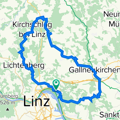
Linz/Strobl
A cycling route starting in Linz, Upper Austria, Austria.
Overview
About this route
Reiserad + Gebäck Training von HBh Linz (Anreise Wien -Westbahn) 0900-1500 ohne Pausen 135km! teilweise Gelände
R4 entlang sehr schön
- -:--
- Duration
- 115 km
- Distance
- 456 m
- Ascent
- 171 m
- Descent
- ---
- Avg. speed
- ---
- Max. altitude

Route photos


Route quality
Waytypes & surfaces along the route
Waytypes
Quiet road
42.6 km
(37 %)
Path
26.5 km
(23 %)
Surfaces
Paved
66.7 km
(58 %)
Unpaved
2.3 km
(2 %)
Asphalt
63.3 km
(55 %)
Paved (undefined)
3.5 km
(3 %)
Continue with Bikemap
Use, edit, or download this cycling route
You would like to ride Linz/Strobl or customize it for your own trip? Here is what you can do with this Bikemap route:
Free features
- Save this route as favorite or in collections
- Copy & plan your own version of this route
- Split it into stages to create a multi-day tour
- Sync your route with Garmin or Wahoo
Premium features
Free trial for 3 days, or one-time payment. More about Bikemap Premium.
- Navigate this route on iOS & Android
- Export a GPX / KML file of this route
- Create your custom printout (try it for free)
- Download this route for offline navigation
Discover more Premium features.
Get Bikemap PremiumFrom our community
Other popular routes starting in Linz
 Lange Ausfahrt durch Linz
- Distance
- 45 km
- Ascent
- 634 m
- Descent
- 622 m
- Location
- Linz, Upper Austria, Austria
 Giselawarte - GIS
- Distance
- 27.7 km
- Ascent
- 914 m
- Descent
- 834 m
- Location
- Linz, Upper Austria, Austria
 Lichtenberg, Mirellental, Pfenningberg CLONED FROM ROUTE 38001
- Distance
- 54.3 km
- Ascent
- 1,090 m
- Descent
- 1,093 m
- Location
- Linz, Upper Austria, Austria
 Süden von Linz
- Distance
- 42.4 km
- Ascent
- 186 m
- Descent
- 187 m
- Location
- Linz, Upper Austria, Austria
 St. Martin- Lichtenhah-Lichtenberg
- Distance
- 73.2 km
- Ascent
- 1,240 m
- Descent
- 1,241 m
- Location
- Linz, Upper Austria, Austria
 Pferdeeisenbahn-Innertreffling-Forst-Pulgarn-Steyregg-Pfenningberg-Plesching
- Distance
- 42.8 km
- Ascent
- 674 m
- Descent
- 677 m
- Location
- Linz, Upper Austria, Austria
 Steyregg Runde
- Distance
- 22 km
- Ascent
- 218 m
- Descent
- 220 m
- Location
- Linz, Upper Austria, Austria
 Oberbairing-Altenberg-Galli-Linz
- Distance
- 27.8 km
- Ascent
- 496 m
- Descent
- 496 m
- Location
- Linz, Upper Austria, Austria
Open it in the app