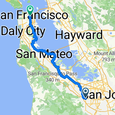
Stevens-Eden Mish Mash
A cycling route starting in Cupertino, California, United States of America.
Overview
About this route
- -:--
- Duration
- 33.9 km
- Distance
- 588 m
- Ascent
- 591 m
- Descent
- ---
- Avg. speed
- ---
- Avg. speed
Route quality
Waytypes & surfaces along the route
Waytypes
Road
18.3 km
(54 %)
Quiet road
11.1 km
(33 %)
Surfaces
Paved
30.7 km
(90 %)
Asphalt
30.5 km
(90 %)
Concrete
0.1 km
(<1 %)
Continue with Bikemap
Use, edit, or download this cycling route
You would like to ride Stevens-Eden Mish Mash or customize it for your own trip? Here is what you can do with this Bikemap route:
Free features
- Save this route as favorite or in collections
- Copy & plan your own version of this route
- Sync your route with Garmin or Wahoo
Premium features
Free trial for 3 days, or one-time payment. More about Bikemap Premium.
- Navigate this route on iOS & Android
- Export a GPX / KML file of this route
- Create your custom printout (try it for free)
- Download this route for offline navigation
Discover more Premium features.
Get Bikemap PremiumFrom our community
Other popular routes starting in Cupertino
- Relaxed route in Cupertino
- Distance
- 5.4 km
- Ascent
- 74 m
- Descent
- 16 m
- Location
- Cupertino, California, United States of America
- home road loop
- Distance
- 30.4 km
- Ascent
- 304 m
- Descent
- 304 m
- Location
- Cupertino, California, United States of America
- Chuck's pretty ride.
- Distance
- 22.7 km
- Ascent
- 325 m
- Descent
- 326 m
- Location
- Cupertino, California, United States of America
- 1 Infinite Loop, Cupertino to 10788–10910 N Blaney Ave, Cupertino
- Distance
- 4 km
- Ascent
- 0 m
- Descent
- 0 m
- Location
- Cupertino, California, United States of America
- Stevens Creek - Redwood Gulch - Skyline - Page Mill Loop
- Distance
- 51 km
- Ascent
- 923 m
- Descent
- 923 m
- Location
- Cupertino, California, United States of America
- Cupertino Redwood Gulch
- Distance
- 31.7 km
- Ascent
- 634 m
- Descent
- 629 m
- Location
- Cupertino, California, United States of America
- Gorgeous Santa Cruz Trip
- Distance
- 125.6 km
- Ascent
- 1,240 m
- Descent
- 1,241 m
- Location
- Cupertino, California, United States of America
- To the coast and back V3
- Distance
- 144.9 km
- Ascent
- 1,853 m
- Descent
- 1,853 m
- Location
- Cupertino, California, United States of America
Open it in the app