
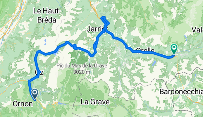
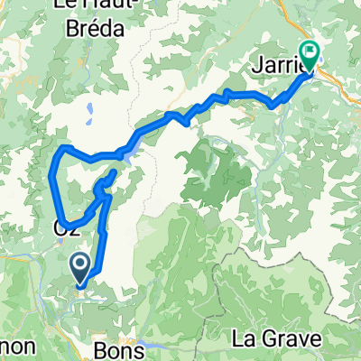
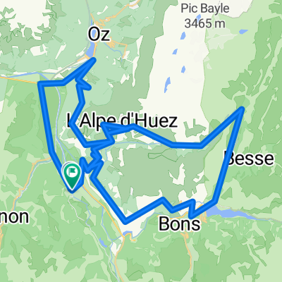
Overview
About this route
- -:--
- Duration
- 114.7 km
- Distance
- 2,275 m
- Ascent
- 1,927 m
- Descent
- ---
- Avg. speed
- ---
- Max. altitude

Part of
Francia_2018
4 stages
Route quality
Waytypes & surfaces along the route
Waytypes
Road
21.8 km
(19 %)
Quiet road
3.4 km
(3 %)
Undefined
89.5 km
(78 %)
Surfaces
Paved
68.8 km
(60 %)
Asphalt
68.8 km
(60 %)
Undefined
45.9 km
(40 %)
Route highlights
Points of interest along the route
Point of interest after 3.4 km
Pas de la Confession 1530m

Point of interest after 36.1 km
Col du Glandon 1924m
Point of interest after 39 km
Col de la Croix de Fer 2067m

Point of interest after 75.3 km
Mont Vernier

Point of interest after 94.6 km
Col du Telegraphe 1566 m
Continue with Bikemap
Use, edit, or download this cycling route
You would like to ride Francia_2018_3 or customize it for your own trip? Here is what you can do with this Bikemap route:
Free features
- Save this route as favorite or in collections
- Copy & plan your own version of this route
- Split it into stages to create a multi-day tour
- Sync your route with Garmin or Wahoo
Premium features
Free trial for 3 days, or one-time payment. More about Bikemap Premium.
- Navigate this route on iOS & Android
- Export a GPX / KML file of this route
- Create your custom printout (try it for free)
- Download this route for offline navigation
Discover more Premium features.
Get Bikemap PremiumFrom our community
Other popular routes starting in Huez
 Day 7 - Alpe d'Huez, Col Du Sabot, Glandon
- Distance
- 80.9 km
- Ascent
- 3,674 m
- Descent
- 4,932 m
- Location
- Huez, Auvergne-Rhône-Alpes, France
 ALPES008- BURG D OISEANS-ALPE DUEZ-COL DE LA SERRETTE
- Distance
- 92.6 km
- Ascent
- 2,565 m
- Descent
- 2,563 m
- Location
- Huez, Auvergne-Rhône-Alpes, France
 Frankreich 2008 4.Etappe Col Croix de Fer
- Distance
- 32.2 km
- Ascent
- 1,664 m
- Descent
- 321 m
- Location
- Huez, Auvergne-Rhône-Alpes, France
 Rhone-Alpes: Etappe 4
- Distance
- 99.6 km
- Ascent
- 1,771 m
- Descent
- 2,412 m
- Location
- Huez, Auvergne-Rhône-Alpes, France
 Col de la Sarenne, Auris, and Maronne
- Distance
- 76.9 km
- Ascent
- 2,346 m
- Descent
- 2,346 m
- Location
- Huez, Auvergne-Rhône-Alpes, France
 alpes-2012 Allemont-croix de fer-glandon
- Distance
- 117.7 km
- Ascent
- 3,000 m
- Descent
- 3,000 m
- Location
- Huez, Auvergne-Rhône-Alpes, France
 L'Alpe d'Huez
- Distance
- 60.3 km
- Ascent
- 1,850 m
- Descent
- 1,850 m
- Location
- Huez, Auvergne-Rhône-Alpes, France
 Col du Sabot
- Distance
- 38.8 km
- Ascent
- 1,445 m
- Descent
- 1,443 m
- Location
- Huez, Auvergne-Rhône-Alpes, France
Open it in the app