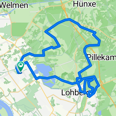
Standardrunde ca. 30km
A cycling route starting in Voerde, North Rhine-Westphalia, Germany.
Overview
About this route
Recht abwechslungsreiche Runde mit wenigen, kurzen Anstiegen zu Beginn durch den Hünxer Wald, und langen flachen Teilstücken bis über Dinslaken
- -:--
- Duration
- 29.2 km
- Distance
- 65 m
- Ascent
- 68 m
- Descent
- ---
- Avg. speed
- 69 m
- Avg. speed
Route quality
Waytypes & surfaces along the route
Waytypes
Path
13.8 km
(47 %)
Quiet road
9.3 km
(32 %)
Surfaces
Paved
21.3 km
(73 %)
Unpaved
0.4 km
(1 %)
Asphalt
21.3 km
(73 %)
Unpaved (undefined)
0.4 km
(1 %)
Continue with Bikemap
Use, edit, or download this cycling route
You would like to ride Standardrunde ca. 30km or customize it for your own trip? Here is what you can do with this Bikemap route:
Free features
- Save this route as favorite or in collections
- Copy & plan your own version of this route
- Sync your route with Garmin or Wahoo
Premium features
Free trial for 3 days, or one-time payment. More about Bikemap Premium.
- Navigate this route on iOS & Android
- Export a GPX / KML file of this route
- Create your custom printout (try it for free)
- Download this route for offline navigation
Discover more Premium features.
Get Bikemap PremiumFrom our community
Other popular routes starting in Voerde
- Kronprinzenstraße 37, Voerde (Niederrhein) nach Kronprinzenstraße 15, Voerde (Niederrhein)
- Distance
- 49 km
- Ascent
- 232 m
- Descent
- 235 m
- Location
- Voerde, North Rhine-Westphalia, Germany
- Mühlenbach - Tester Berge
- Distance
- 28.6 km
- Ascent
- 94 m
- Descent
- 96 m
- Location
- Voerde, North Rhine-Westphalia, Germany
- Landschaftsschutzgebiete über Walsum Südhafen und Hoaglinie dann Mattlerbusch über Lohberg.
- Distance
- 49.9 km
- Ascent
- 201 m
- Descent
- 204 m
- Location
- Voerde, North Rhine-Westphalia, Germany
- Grüne Halde
- Distance
- 32.2 km
- Ascent
- 168 m
- Descent
- 169 m
- Location
- Voerde, North Rhine-Westphalia, Germany
- NR204: Rotbach, Rhein und Kanal
- Distance
- 40.3 km
- Ascent
- 175 m
- Descent
- 175 m
- Location
- Voerde, North Rhine-Westphalia, Germany
- Parkstraße 11, Voerde (Niederrhein) nach Parkstraße 11, Voerde (Niederrhein)
- Distance
- 32.9 km
- Ascent
- 40 m
- Descent
- 85 m
- Location
- Voerde, North Rhine-Westphalia, Germany
- Standardrunde ca. 30km
- Distance
- 29.2 km
- Ascent
- 65 m
- Descent
- 68 m
- Location
- Voerde, North Rhine-Westphalia, Germany
- Marberts Grafenmühle-Tour 11.7.2010
- Distance
- 45.5 km
- Ascent
- 140 m
- Descent
- 140 m
- Location
- Voerde, North Rhine-Westphalia, Germany