

2017.09.11 - PersonalRecord Tour
A cycling route starting in Olching, Bavaria, Germany.
Overview
About this route
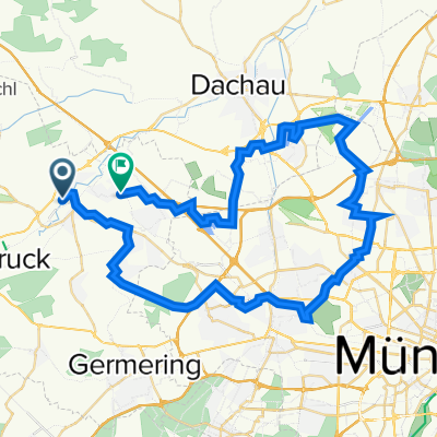
80km was my target for this undefined, only roughly studied tour. With different conditions throughout the entire day, this trip ended quite euphoric as I had set my own highest ever personal record when it comes to total distance ridden in one day...
- -:--
- Duration
- 101.8 km
- Distance
- 150 m
- Ascent
- 148 m
- Descent
- ---
- Avg. speed
- ---
- Max. altitude

Route quality
Waytypes & surfaces along the route
Waytypes
Quiet road
35.6 km
(35 %)
Track
22.4 km
(22 %)
Surfaces
Paved
71.3 km
(70 %)
Unpaved
23.4 km
(23 %)
Asphalt
70.3 km
(69 %)
Gravel
10.2 km
(10 %)
Route highlights
Points of interest along the route
Point of interest after 18.1 km
Trachtengalerie Mammendorf
Continue with Bikemap
Use, edit, or download this cycling route
You would like to ride 2017.09.11 - PersonalRecord Tour or customize it for your own trip? Here is what you can do with this Bikemap route:
Free features
- Save this route as favorite or in collections
- Copy & plan your own version of this route
- Split it into stages to create a multi-day tour
- Sync your route with Garmin or Wahoo
Premium features
Free trial for 3 days, or one-time payment. More about Bikemap Premium.
- Navigate this route on iOS & Android
- Export a GPX / KML file of this route
- Create your custom printout (try it for free)
- Download this route for offline navigation
Discover more Premium features.
Get Bikemap PremiumFrom our community
Other popular routes starting in Olching
 Olching Emmering Olching
- Distance
- 16.6 km
- Ascent
- 16 m
- Descent
- 14 m
- Location
- Olching, Bavaria, Germany
 Sieben-Seen-Runde
- Distance
- 54 km
- Ascent
- 67 m
- Descent
- 67 m
- Location
- Olching, Bavaria, Germany
 Olching-Emmering-FFB-Jesenwang-Schöngeising-FFB-Emmering-Olching
- Distance
- 43.8 km
- Ascent
- 126 m
- Descent
- 126 m
- Location
- Olching, Bavaria, Germany
 ?ŸX ? nach ?ŸX ?
- Distance
- 62.3 km
- Ascent
- 492 m
- Descent
- 491 m
- Location
- Olching, Bavaria, Germany
 Olching - Rundweg - Olching
- Distance
- 27.5 km
- Ascent
- 32 m
- Descent
- 32 m
- Location
- Olching, Bavaria, Germany
 Hinterland rundfahrt übers Maisacher Volksfest
- Distance
- 28 km
- Ascent
- 27 m
- Descent
- 29 m
- Location
- Olching, Bavaria, Germany
 Esting - Mammendorf
- Distance
- 14.2 km
- Ascent
- 51 m
- Descent
- 28 m
- Location
- Olching, Bavaria, Germany
 Rund um Olching 2
- Distance
- 20.7 km
- Ascent
- 18 m
- Descent
- 20 m
- Location
- Olching, Bavaria, Germany
Open it in the app