

Overview
About this route
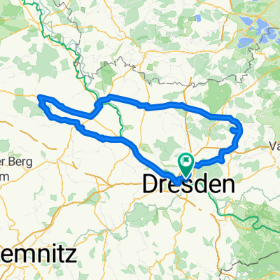
Wenn ihr diese Route fahrt dann kommt ihr zum wachwitzer höhenpark.
Dort kann man prima Downhill und MTB Fahren.
Viel Spaß!
- -:--
- Duration
- 4.7 km
- Distance
- 161 m
- Ascent
- 11 m
- Descent
- ---
- Avg. speed
- ---
- Max. altitude

Part of
Downhill
1 stage
Continue with Bikemap
Use, edit, or download this cycling route
You would like to ride Weg- Wachwitzer Höhenpark or customize it for your own trip? Here is what you can do with this Bikemap route:
Free features
- Save this route as favorite or in collections
- Copy & plan your own version of this route
- Sync your route with Garmin or Wahoo
Premium features
Free trial for 3 days, or one-time payment. More about Bikemap Premium.
- Navigate this route on iOS & Android
- Export a GPX / KML file of this route
- Create your custom printout (try it for free)
- Download this route for offline navigation
Discover more Premium features.
Get Bikemap PremiumFrom our community
Other popular routes starting in Dresden
 Dresden - Stolpen -Rathen
- Distance
- 54 km
- Ascent
- 447 m
- Descent
- 446 m
- Location
- Dresden, Saxony, Germany
 Pre Velorace Trainingsausfahrt 2015 Einsteiger
- Distance
- 44.6 km
- Ascent
- 222 m
- Descent
- 222 m
- Location
- Dresden, Saxony, Germany
 Ponickau
- Distance
- 122.5 km
- Ascent
- 320 m
- Descent
- 323 m
- Location
- Dresden, Saxony, Germany
 Rennradrunde um den Tharandter Wald
- Distance
- 78.9 km
- Ascent
- 934 m
- Descent
- 850 m
- Location
- Dresden, Saxony, Germany
 DD-Collm-Riesa-Keulenberg-DD
- Distance
- 196.8 km
- Ascent
- 1,000 m
- Descent
- 904 m
- Location
- Dresden, Saxony, Germany
 Schmorsdorfer Höhenrunde
- Distance
- 49.8 km
- Ascent
- 510 m
- Descent
- 488 m
- Location
- Dresden, Saxony, Germany
 Dresden - Prag
- Distance
- 217.2 km
- Ascent
- 388 m
- Descent
- 303 m
- Location
- Dresden, Saxony, Germany
 Dresden - Glashütte - Bahratal
- Distance
- 90.4 km
- Ascent
- 1,112 m
- Descent
- 1,142 m
- Location
- Dresden, Saxony, Germany
Open it in the app