

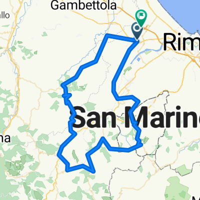
S. Arcangelo Romagna - Pennabilli
A cycling route starting in Santarcangelo di Romagna, Emilia-Romagna, Italy.
Overview
About this route
- -:--
- Duration
- 55.3 km
- Distance
- 1,050 m
- Ascent
- 518 m
- Descent
- ---
- Avg. speed
- ---
- Max. altitude

Route quality
Waytypes & surfaces along the route
Waytypes
Road
23 km
(42 %)
Busy road
20.5 km
(37 %)
Surfaces
Paved
36.6 km
(66 %)
Asphalt
36.6 km
(66 %)
Undefined
18.6 km
(34 %)
Continue with Bikemap
Use, edit, or download this cycling route
You would like to ride S. Arcangelo Romagna - Pennabilli or customize it for your own trip? Here is what you can do with this Bikemap route:
Free features
- Save this route as favorite or in collections
- Copy & plan your own version of this route
- Sync your route with Garmin or Wahoo
Premium features
Free trial for 3 days, or one-time payment. More about Bikemap Premium.
- Navigate this route on iOS & Android
- Export a GPX / KML file of this route
- Create your custom printout (try it for free)
- Download this route for offline navigation
Discover more Premium features.
Get Bikemap PremiumFrom our community
Other popular routes starting in Santarcangelo di Romagna
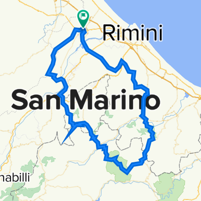
 San Marino - San Leo - Novafeltria
- Distance
- 107.3 km
- Ascent
- 2,541 m
- Descent
- 2,351 m
- Location
- Santarcangelo di Romagna, Emilia-Romagna, Italy
 5 salite
- Distance
- 82 km
- Ascent
- 1,001 m
- Descent
- 1,004 m
- Location
- Santarcangelo di Romagna, Emilia-Romagna, Italy
 Moderate route in Rimini
- Distance
- 11.4 km
- Ascent
- 4 m
- Descent
- 40 m
- Location
- Santarcangelo di Romagna, Emilia-Romagna, Italy
 Tag 4 Santarcangelo di Romagna - San Marino
- Distance
- 24.6 km
- Ascent
- 693 m
- Descent
- 46 m
- Location
- Santarcangelo di Romagna, Emilia-Romagna, Italy
 MSBG San Marino
- Distance
- 57.5 km
- Ascent
- 974 m
- Descent
- 1,002 m
- Location
- Santarcangelo di Romagna, Emilia-Romagna, Italy
 Bellaria
- Distance
- 20.5 km
- Ascent
- 8 m
- Descent
- 49 m
- Location
- Santarcangelo di Romagna, Emilia-Romagna, Italy
 Caduti da Piccoli Tour 2017 - Seconda Tappa
- Distance
- 154.7 km
- Ascent
- 844 m
- Descent
- 844 m
- Location
- Santarcangelo di Romagna, Emilia-Romagna, Italy
 Santarcangelo - Gemmano - Santarcangelo - Gemmano
- Distance
- 98 km
- Ascent
- 2,397 m
- Descent
- 2,395 m
- Location
- Santarcangelo di Romagna, Emilia-Romagna, Italy
Open it in the app