

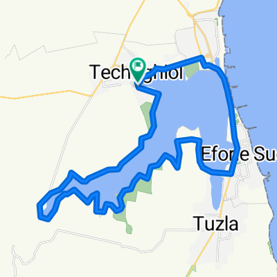
Quick ride through Techirghiol bike track
A cycling route starting in Techirghiol, Constanța County, Romania.
Overview
About this route
- 16 min
- Duration
- 4.1 km
- Distance
- 0 m
- Ascent
- 0 m
- Descent
- 15.9 km/h
- Avg. speed
- ---
- Max. altitude

Route quality
Waytypes & surfaces along the route
Waytypes
Cycleway
3.7 km
(89 %)
Quiet road
0.4 km
(9 %)
Surfaces
Paved
4.1 km
(99 %)
Asphalt
3 km
(73 %)
Paved (undefined)
1.1 km
(26 %)
Undefined
0 km
(1 %)
Continue with Bikemap
Use, edit, or download this cycling route
You would like to ride Quick ride through Techirghiol bike track or customize it for your own trip? Here is what you can do with this Bikemap route:
Free features
- Save this route as favorite or in collections
- Copy & plan your own version of this route
- Sync your route with Garmin or Wahoo
Premium features
Free trial for 3 days, or one-time payment. More about Bikemap Premium.
- Navigate this route on iOS & Android
- Export a GPX / KML file of this route
- Create your custom printout (try it for free)
- Download this route for offline navigation
Discover more Premium features.
Get Bikemap PremiumFrom our community
Other popular routes starting in Techirghiol
 Quick ride through Techirghiol bike track
- Distance
- 4.1 km
- Ascent
- 0 m
- Descent
- 0 m
- Location
- Techirghiol, Constanța County, Romania
 Constanta - Techirghiol
- Distance
- 2 km
- Ascent
- 0 m
- Descent
- 0 m
- Location
- Techirghiol, Constanța County, Romania
 In jurul lacului Techirghiol
- Distance
- 30 km
- Ascent
- 112 m
- Descent
- 116 m
- Location
- Techirghiol, Constanța County, Romania
 Techirghiol
- Distance
- 14.8 km
- Ascent
- 91 m
- Descent
- 89 m
- Location
- Techirghiol, Constanța County, Romania
 Brief bike tour through Techirghiol
- Distance
- 6.4 km
- Ascent
- 12 m
- Descent
- 12 m
- Location
- Techirghiol, Constanța County, Romania
 Route from Strada Traian, Techirghiol
- Distance
- 15.8 km
- Ascent
- 0 m
- Descent
- 11 m
- Location
- Techirghiol, Constanța County, Romania
 Strada Eforiei, Techirghiol to Strada Eforiei, Techirghiol
- Distance
- 55.4 km
- Ascent
- 279 m
- Descent
- 282 m
- Location
- Techirghiol, Constanța County, Romania
 Techirghiol-Biruința-Crucea lui Makensen-Moșneni-23August-Plaja 23August-Tuzla -Techirghiol
- Distance
- 62.3 km
- Ascent
- 295 m
- Descent
- 301 m
- Location
- Techirghiol, Constanța County, Romania
Open it in the app