Vallon Pont d'Arc-Les Salelles-Laulagnier-St.Remeze-Vallon
A cycling route starting in Ruoms, Auvergne-Rh么ne-Alpes, France.
Overview
About this route
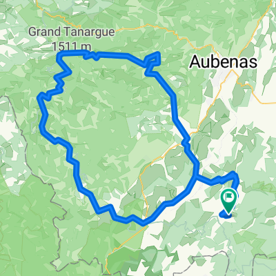
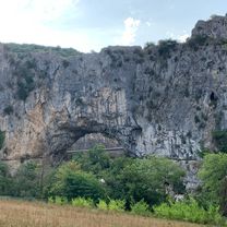
Secondary road from Salavas to Les Salelles. Then a gravel track to the remote g卯te 'Laulagner'. Now it gets very rough, with sections that require pushing, but mostly rideable up to the Col de Rez. Next follows a long high-route path and later a small road through the beautiful countryside. Once the main road is reached it goes quickly to St. Rem猫ze. Via lavender fields and a museum you finally reach the big gorge road above the Ard猫che. After the viewpoint there is a very fast descent down to the river. On the return the Pont d'Arc appears as a POI, visible from both sides! Now back on the busy main road to Vallon.
- 3 h 59 min
- Duration
- 46.8 km
- Distance
- 773 m
- Ascent
- 774 m
- Descent
- 11.8 km/h
- Avg. speed
- 483 m
- Max. altitude
Route photos
Route quality
Waytypes & surfaces along the route
Waytypes
Road
11.2 km
(24 %)
Quiet road
8 km
(17 %)
Surfaces
Paved
33.7 km
(72 %)
Unpaved
6.6 km
(14 %)
Asphalt
33.7 km
(72 %)
Unpaved (undefined)
5.1 km
(11 %)
Continue with Bikemap
Use, edit, or download this cycling route
You would like to ride Vallon Pont d'Arc-Les Salelles-Laulagnier-St.Remeze-Vallon or customize it for your own trip? Here is what you can do with this Bikemap route:
Free features
- Save this route as favorite or in collections
- Copy & plan your own version of this route
- Sync your route with Garmin or Wahoo
Premium features
Free trial for 3 days, or one-time payment. More about Bikemap Premium.
- Navigate this route on iOS & Android
- Export a GPX / KML file of this route
- Create your custom printout (try it for free)
- Download this route for offline navigation
Discover more Premium features.
Get Bikemap PremiumFrom our community
Other popular routes starting in Ruoms
frr_ardeche_vpd_110km- Distance
- 110.9 km
- Ascent
- 871 m
- Descent
- 867 m
- Location
- Ruoms, Auvergne-Rh么ne-Alpes, France
Chemin de Sevenier, Lagorce naar Chemin de Sevenier, Lagorce- Distance
- 37.5 km
- Ascent
- 559 m
- Descent
- 558 m
- Location
- Ruoms, Auvergne-Rh么ne-Alpes, France
Sampzon-Chandolas-Col de la Serre-Salavas- Distance
- 47.6 km
- Ascent
- 1,030 m
- Descent
- 1,029 m
- Location
- Ruoms, Auvergne-Rh么ne-Alpes, France
lagorce bouvier- Distance
- 16.3 km
- Ascent
- 1,967 m
- Descent
- 1,977 m
- Location
- Ruoms, Auvergne-Rh么ne-Alpes, France
Ardeche Runde- Distance
- 47.6 km
- Ascent
- 1,102 m
- Descent
- 1,003 m
- Location
- Ruoms, Auvergne-Rh么ne-Alpes, France
Vallon Pont d'Arc -Bidon-Gorges Ard猫che- Distance
- 51.8 km
- Ascent
- 594 m
- Descent
- 594 m
- Location
- Ruoms, Auvergne-Rh么ne-Alpes, France
Ruoms - Vallon Pont d'Arc 32 km- Distance
- 32.4 km
- Ascent
- 383 m
- Descent
- 383 m
- Location
- Ruoms, Auvergne-Rh么ne-Alpes, France
Chemin de Faussimagne, Chauzon nach Chemin de Faussimagne, Chauzon- Distance
- 29.1 km
- Ascent
- 269 m
- Descent
- 271 m
- Location
- Ruoms, Auvergne-Rh么ne-Alpes, France
Open it in the app


