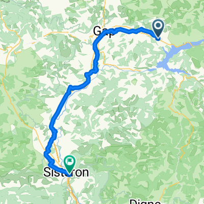
chorges montgardin batie neuve
A cycling route starting in Chorges, Provence-Alpes-C么te d'Azur Region, France.
Overview
About this route
- -:--
- Duration
- 17.3 km
- Distance
- 313 m
- Ascent
- 311 m
- Descent
- ---
- Avg. speed
- ---
- Avg. speed
Route quality
Waytypes & surfaces along the route
Waytypes
Road
7.6 km
(44 %)
Track
5.4 km
(31 %)
Surfaces
Paved
0.9 km
(5 %)
Unpaved
4.2 km
(24 %)
Gravel
3.9 km
(22 %)
Asphalt
0.9 km
(5 %)
Continue with Bikemap
Use, edit, or download this cycling route
You would like to ride chorges montgardin batie neuve or customize it for your own trip? Here is what you can do with this Bikemap route:
Free features
- Save this route as favorite or in collections
- Copy & plan your own version of this route
- Sync your route with Garmin or Wahoo
Premium features
Free trial for 3 days, or one-time payment. More about Bikemap Premium.
- Navigate this route on iOS & Android
- Export a GPX / KML file of this route
- Create your custom printout (try it for free)
- Download this route for offline navigation
Discover more Premium features.
Get Bikemap PremiumFrom our community
Other popular routes starting in Chorges
- Sud de Serre-Pon莽on et Gap
- Distance
- 118.3 km
- Ascent
- 1,522 m
- Descent
- 1,519 m
- Location
- Chorges, Provence-Alpes-C么te d'Azur Region, France
- Montagne du Fein
- Distance
- 19.5 km
- Ascent
- 555 m
- Descent
- 553 m
- Location
- Chorges, Provence-Alpes-C么te d'Azur Region, France
- Barcelonnette 12 juni 2017
- Distance
- 61.2 km
- Ascent
- 1,676 m
- Descent
- 1,931 m
- Location
- Chorges, Provence-Alpes-C么te d'Azur Region, France
- 3. Tag Prunieres - Sisteron
- Distance
- 91.5 km
- Ascent
- 651 m
- Descent
- 948 m
- Location
- Chorges, Provence-Alpes-C么te d'Azur Region, France
- chorges montgardin batie neuve
- Distance
- 17.3 km
- Ascent
- 313 m
- Descent
- 311 m
- Location
- Chorges, Provence-Alpes-C么te d'Azur Region, France
- Serre Pon莽on - N掳1 - 95km D+ 2000
- Distance
- 94.3 km
- Ascent
- 2,312 m
- Descent
- 2,312 m
- Location
- Chorges, Provence-Alpes-C么te d'Azur Region, France
- gravel bike chorges croix des pr茅 Rousset Chorges
- Distance
- 36.3 km
- Ascent
- 1,095 m
- Descent
- 1,097 m
- Location
- Chorges, Provence-Alpes-C么te d'Azur Region, France
- Serre Pon莽on cime de la bonnette -150KMS
- Distance
- 65 km
- Ascent
- 2,322 m
- Descent
- 660 m
- Location
- Chorges, Provence-Alpes-C么te d'Azur Region, France
Open it in the app