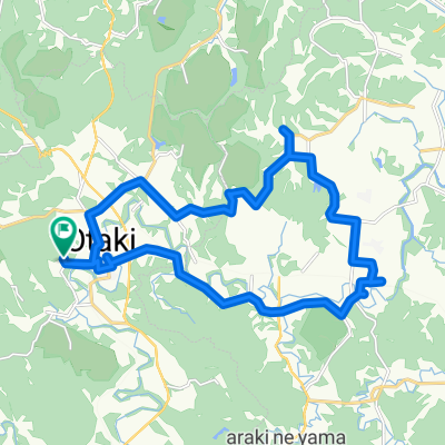
BR-EW-Taitozaki-Futtsu
A cycling route starting in Ōhara, Chiba, Japan.
Overview
About this route
- -:--
- Duration
- 76.4 km
- Distance
- 468 m
- Ascent
- 514 m
- Descent
- ---
- Avg. speed
- ---
- Avg. speed
Route quality
Waytypes & surfaces along the route
Waytypes
Busy road
43 km
(56 %)
Quiet road
15.4 km
(20 %)
Surfaces
Paved
10.9 km
(14 %)
Asphalt
9.5 km
(12 %)
Paved (undefined)
1.4 km
(2 %)
Undefined
65.5 km
(86 %)
Continue with Bikemap
Use, edit, or download this cycling route
You would like to ride BR-EW-Taitozaki-Futtsu or customize it for your own trip? Here is what you can do with this Bikemap route:
Free features
- Save this route as favorite or in collections
- Copy & plan your own version of this route
- Sync your route with Garmin or Wahoo
Premium features
Free trial for 3 days, or one-time payment. More about Bikemap Premium.
- Navigate this route on iOS & Android
- Export a GPX / KML file of this route
- Create your custom printout (try it for free)
- Download this route for offline navigation
Discover more Premium features.
Get Bikemap PremiumFrom our community
Other popular routes starting in Ōhara
- BR-CCT-Otaki-Ohara-Ubara-Circuit
- Distance
- 65.6 km
- Ascent
- 402 m
- Descent
- 399 m
- Location
- Ōhara, Chiba, Japan
- Ohara-HonChiba
- Distance
- 65.5 km
- Ascent
- 402 m
- Descent
- 398 m
- Location
- Ōhara, Chiba, Japan
- 大原~勝浦~鴨川
- Distance
- 54.8 km
- Ascent
- 379 m
- Descent
- 383 m
- Location
- Ōhara, Chiba, Japan
- 列車を使って一回り
- Distance
- 47.9 km
- Ascent
- 308 m
- Descent
- 333 m
- Location
- Ōhara, Chiba, Japan
- BAC-Otaki-Kuniyoshi
- Distance
- 23.3 km
- Ascent
- 244 m
- Descent
- 244 m
- Location
- Ōhara, Chiba, Japan
- BAC-Kuniyoshi-Ohara
- Distance
- 34.6 km
- Ascent
- 132 m
- Descent
- 133 m
- Location
- Ōhara, Chiba, Japan
- BR-EW-Taitozaki-Futtsu
- Distance
- 76.4 km
- Ascent
- 468 m
- Descent
- 514 m
- Location
- Ōhara, Chiba, Japan
- CYCLO GRAPH完成記念サイクリング
- Distance
- 35.4 km
- Ascent
- 529 m
- Descent
- 529 m
- Location
- Ōhara, Chiba, Japan
Open it in the app