

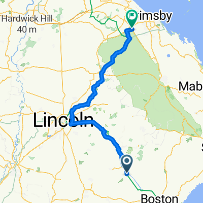
BOSTON SLOG 2017
A cycling route starting in Coningsby, England, United Kingdom.
Overview
About this route
- -:--
- Duration
- 43.7 km
- Distance
- 13 m
- Ascent
- 13 m
- Descent
- ---
- Avg. speed
- ---
- Max. altitude
Route quality
Waytypes & surfaces along the route
Waytypes
Road
27.1 km
(62 %)
Quiet road
11.4 km
(26 %)
Surfaces
Paved
27.1 km
(62 %)
Unpaved
0.4 km
(1 %)
Asphalt
27.1 km
(62 %)
Ground
0.4 km
(1 %)
Undefined
16.2 km
(37 %)
Continue with Bikemap
Use, edit, or download this cycling route
You would like to ride BOSTON SLOG 2017 or customize it for your own trip? Here is what you can do with this Bikemap route:
Free features
- Save this route as favorite or in collections
- Copy & plan your own version of this route
- Sync your route with Garmin or Wahoo
Premium features
Free trial for 3 days, or one-time payment. More about Bikemap Premium.
- Navigate this route on iOS & Android
- Export a GPX / KML file of this route
- Create your custom printout (try it for free)
- Download this route for offline navigation
Discover more Premium features.
Get Bikemap PremiumFrom our community
Other popular routes starting in Coningsby
 Revesby 25 mile via Horncastle
- Distance
- 42.3 km
- Ascent
- 253 m
- Descent
- 255 m
- Location
- Coningsby, England, United Kingdom
 Revesby 2
- Distance
- 33.7 km
- Ascent
- 315 m
- Descent
- 278 m
- Location
- Coningsby, England, United Kingdom
 Boston Slog
- Distance
- 43.4 km
- Ascent
- 15 m
- Descent
- 16 m
- Location
- Coningsby, England, United Kingdom
 Loop round New York
- Distance
- 45.2 km
- Ascent
- 23 m
- Descent
- 22 m
- Location
- Coningsby, England, United Kingdom
 Branston Loop
- Distance
- 99.4 km
- Ascent
- 172 m
- Descent
- 174 m
- Location
- Coningsby, England, United Kingdom
 day 2 to The Willows camping
- Distance
- 86.4 km
- Ascent
- 328 m
- Descent
- 302 m
- Location
- Coningsby, England, United Kingdom
 Coningsby Lunch Loop
- Distance
- 25 km
- Ascent
- 35 m
- Descent
- 36 m
- Location
- Coningsby, England, United Kingdom
 Coningsby to Rothwell
- Distance
- 134.3 km
- Ascent
- 415 m
- Descent
- 300 m
- Location
- Coningsby, England, United Kingdom
Open it in the app