

dificultades
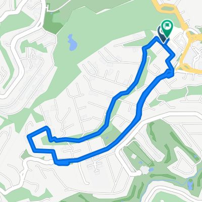
A cycling route starting in San Miguel Hila, State of Mexico, Mexico.
Overview
About this route
good one
- 43 min
- Duration
- 12.2 km
- Distance
- 238 m
- Ascent
- 237 m
- Descent
- 16.9 km/h
- Avg. speed
- ---
- Max. altitude

Route quality
Waytypes & surfaces along the route
Waytypes
Quiet road
1.1 km
(9 %)
Access road
0.1 km
(1 %)
Undefined
11 km
(90 %)
Continue with Bikemap
Use, edit, or download this cycling route
You would like to ride dificultades or customize it for your own trip? Here is what you can do with this Bikemap route:
Free features
- Save this route as favorite or in collections
- Copy & plan your own version of this route
- Sync your route with Garmin or Wahoo
Premium features
Free trial for 3 days, or one-time payment. More about Bikemap Premium.
- Navigate this route on iOS & Android
- Export a GPX / KML file of this route
- Create your custom printout (try it for free)
- Download this route for offline navigation
Discover more Premium features.
Get Bikemap PremiumFrom our community
Other popular routes starting in San Miguel Hila
 De Circuito Oklahoma 26, Villa Nicolás Romero a Calle Mina 5650, Villa Nicolás Romero
- Distance
- 29.3 km
- Ascent
- 2,185 m
- Descent
- 2,240 m
- Location
- San Miguel Hila, State of Mexico, Mexico
 bike tour through
- Distance
- 10.9 km
- Ascent
- 230 m
- Descent
- 233 m
- Location
- San Miguel Hila, State of Mexico, Mexico
 De Oklahoma 34, Villa Nicolás Romero a Manuel Ávila Camacho 8, Villa Nicolás Romero
- Distance
- 38.4 km
- Ascent
- 503 m
- Descent
- 559 m
- Location
- San Miguel Hila, State of Mexico, Mexico
 dificultades
- Distance
- 12.2 km
- Ascent
- 238 m
- Descent
- 237 m
- Location
- San Miguel Hila, State of Mexico, Mexico
 De Circuito Oklahoma 26, Villa Nicolás Romero a Andador Adolfo López Mateos 2, Villa Nicolás Romero
- Distance
- 33.2 km
- Ascent
- 1,376 m
- Descent
- 1,385 m
- Location
- San Miguel Hila, State of Mexico, Mexico
 Hacienda VE
- Distance
- 7.3 km
- Ascent
- 131 m
- Descent
- 124 m
- Location
- San Miguel Hila, State of Mexico, Mexico
 Recovered Route
- Distance
- 9.1 km
- Ascent
- 439 m
- Descent
- 455 m
- Location
- San Miguel Hila, State of Mexico, Mexico
 De Sendero de la Alameda, Ciudad de México a Sendero Llano Grande, Ciudad de México
- Distance
- 12.3 km
- Ascent
- 382 m
- Descent
- 374 m
- Location
- San Miguel Hila, State of Mexico, Mexico
Open it in the app