

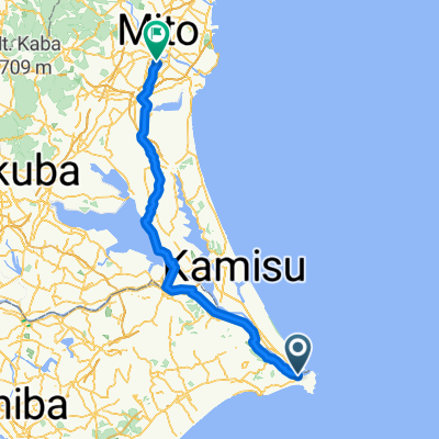
BR-WS-Choshi-Sekiyado
A cycling route starting in Hasaki, Chiba, Japan.
Overview
About this route
- -:--
- Duration
- 126.9 km
- Distance
- 47 m
- Ascent
- 34 m
- Descent
- ---
- Avg. speed
- ---
- Max. altitude

Continue with Bikemap
Use, edit, or download this cycling route
You would like to ride BR-WS-Choshi-Sekiyado or customize it for your own trip? Here is what you can do with this Bikemap route:
Free features
- Save this route as favorite or in collections
- Copy & plan your own version of this route
- Split it into stages to create a multi-day tour
- Sync your route with Garmin or Wahoo
Premium features
Free trial for 3 days, or one-time payment. More about Bikemap Premium.
- Navigate this route on iOS & Android
- Export a GPX / KML file of this route
- Create your custom printout (try it for free)
- Download this route for offline navigation
Discover more Premium features.
Get Bikemap PremiumFrom our community
Other popular routes starting in Hasaki
 BR-WS-Choshi-Sekiyado
- Distance
- 126.9 km
- Ascent
- 47 m
- Descent
- 34 m
- Location
- Hasaki, Chiba, Japan
 BR-Chosi
- Distance
- 10.5 km
- Ascent
- 83 m
- Descent
- 66 m
- Location
- Hasaki, Chiba, Japan
 BRR-WS-Choshi-Kamgawa
- Distance
- 144.8 km
- Ascent
- 285 m
- Descent
- 282 m
- Location
- Hasaki, Chiba, Japan
 千葉県 Chiba
- Distance
- 2,498.4 km
- Ascent
- 2,010 m
- Descent
- 2,017 m
- Location
- Hasaki, Chiba, Japan
 Ronde van Honshu etappe 7 Choshi - Mito
- Distance
- 153 km
- Ascent
- 233 m
- Descent
- 207 m
- Location
- Hasaki, Chiba, Japan
 BR-CSC-Choshi-LightHouse
- Distance
- 40.6 km
- Ascent
- 253 m
- Descent
- 256 m
- Location
- Hasaki, Chiba, Japan
 와카미야초, 조시시에서 주오 1, 미토시까지
- Distance
- 107.3 km
- Ascent
- 341 m
- Descent
- 335 m
- Location
- Hasaki, Chiba, Japan
 BR-EW-Choshi-Ichikawa
- Distance
- 100.7 km
- Ascent
- 255 m
- Descent
- 249 m
- Location
- Hasaki, Chiba, Japan
Open it in the app