

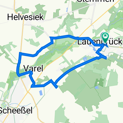
Stemmer Runde - Ultra
A cycling route starting in Lauenbrück, Lower Saxony, Germany.
Overview
About this route
This is the Stemmer Round, Ultra version, that needs to be conquered on Saturday. Under the toughest conditions in the midday heat. DP
- -:--
- Duration
- 17.9 km
- Distance
- 33 m
- Ascent
- 42 m
- Descent
- ---
- Avg. speed
- 46 m
- Max. altitude
Route quality
Waytypes & surfaces along the route
Waytypes
Quiet road
9.8 km
(55 %)
Cycleway
3.6 km
(20 %)
Surfaces
Paved
3.9 km
(22 %)
Unpaved
1.4 km
(8 %)
Asphalt
3.2 km
(18 %)
Unpaved (undefined)
1.3 km
(7 %)
Continue with Bikemap
Use, edit, or download this cycling route
You would like to ride Stemmer Runde - Ultra or customize it for your own trip? Here is what you can do with this Bikemap route:
Free features
- Save this route as favorite or in collections
- Copy & plan your own version of this route
- Sync your route with Garmin or Wahoo
Premium features
Free trial for 3 days, or one-time payment. More about Bikemap Premium.
- Navigate this route on iOS & Android
- Export a GPX / KML file of this route
- Create your custom printout (try it for free)
- Download this route for offline navigation
Discover more Premium features.
Get Bikemap PremiumFrom our community
Other popular routes starting in Lauenbrück
 Feldstraße 2–4, Lauenbrück nach Benkeloher Weg 25, Lauenbrück
- Distance
- 12.5 km
- Ascent
- 27 m
- Descent
- 26 m
- Location
- Lauenbrück, Lower Saxony, Germany
 Velsen - Zwolle + Zwolle - Klein Berßen (2/2) + Klein Berßen - Bremen (2/2) + Bremen - Hamburg (2/2) + Hamburg - Heiligenhafen (1/2)
- Distance
- 143.3 km
- Ascent
- 500 m
- Descent
- 489 m
- Location
- Lauenbrück, Lower Saxony, Germany
 Neue Straße 9, Lauenbrück nach Neue Straße 12, Lauenbrück
- Distance
- 12.9 km
- Ascent
- 27 m
- Descent
- 27 m
- Location
- Lauenbrück, Lower Saxony, Germany
 Stemmer Runde - Ultra
- Distance
- 17.9 km
- Ascent
- 33 m
- Descent
- 42 m
- Location
- Lauenbrück, Lower Saxony, Germany
 Wolfenbüttel-Römö 3. Etappe
- Distance
- 76.5 km
- Ascent
- 146 m
- Descent
- 173 m
- Location
- Lauenbrück, Lower Saxony, Germany
 Lauenbrück
- Distance
- 39.2 km
- Ascent
- 143 m
- Descent
- 114 m
- Location
- Lauenbrück, Lower Saxony, Germany
 Schwarzer Weg 13, Lauenbrück nach Schwarzer Weg 14, Lauenbrück
- Distance
- 15.3 km
- Ascent
- 40 m
- Descent
- 41 m
- Location
- Lauenbrück, Lower Saxony, Germany
 06_Lauenbrück-Stuhr_72km
- Distance
- 72.8 km
- Ascent
- 44 m
- Descent
- 68 m
- Location
- Lauenbrück, Lower Saxony, Germany
Open it in the app